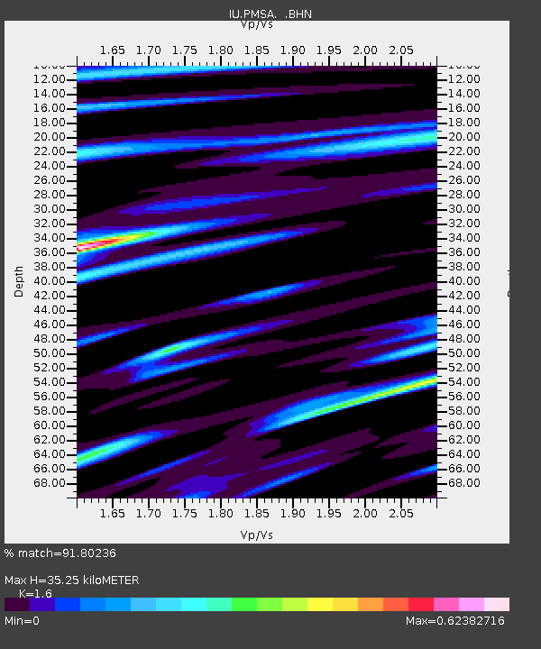
PMSA Palmer Station, Antarctica - Earthquake Result Viewer
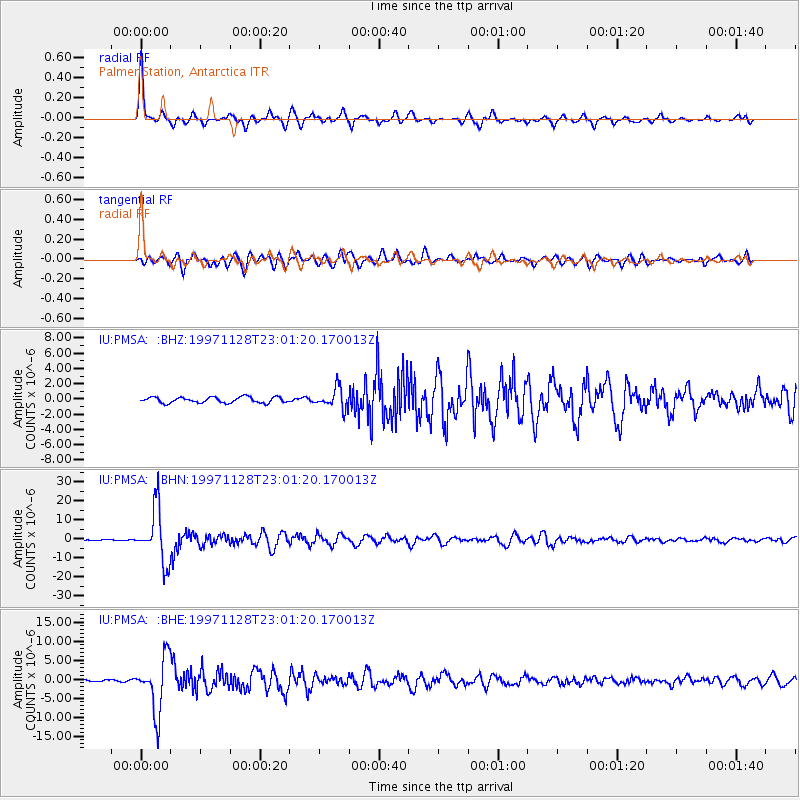
Earthquake location: Peru-Bolivia Border Region
Earthquake latitude/longitude: -13.7/-68.8
Earthquake time(UTC): 1997/11/28 (332) 22:53:41 GMT
Earthquake Depth: 586 km
Earthquake Magnitude: 6.4 MB, 6.6 UNKNOWN, 6.6 MW
Earthquake Catalog/Contributor: WHDF/NEIC
Network: IU Global Seismograph Network (GSN - IRIS/USGS)
Station: PMSA Palmer Station, Antarctica
Lat/Lon: 64.77 S/64.05 W
Elevation: 40 m
Distance: 51.1 deg
Az: 177.392 deg
Baz: 354.077 deg
Ray Param: 0.06495611
Estimated Moho Depth: 35.25 km
Estimated Crust Vp/Vs: 1.60
Assumed Crust Vp: 6.183 km/s
Estimated Crust Vs: 3.864 km/s
Estimated Crust Poisson's Ratio: 0.18
Radial Match: 91.80236 %
Radial Bump: 339
Transverse Match: 77.20932 %
Transverse Bump: 400
SOD ConfigId: 4480
Insert Time: 2010-03-04 15:25:44.435 +0000
GWidth: 2.5
Max Bumps: 400
Tol: 0.001

Signal To Noise

ChannelStoNSTALTA
IU:PMSA: :BHN:19971128T23:01:20.170013Z29.752031.4236745E-54.785134E-7
IU:PMSA: :BHE:19971128T23:01:20.170013Z33.5765087.2873363E-62.1703676E-7
IU:PMSA: :BHZ:19971128T23:01:20.170013Z3.65782641.3517725E-63.6955626E-7
Arrivals
Ps3.6 SECOND
PpPs14 SECOND
PsPs/PpSs18 SECOND