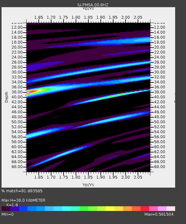
PMSA Palmer Station, Antarctica - Earthquake Result Viewer
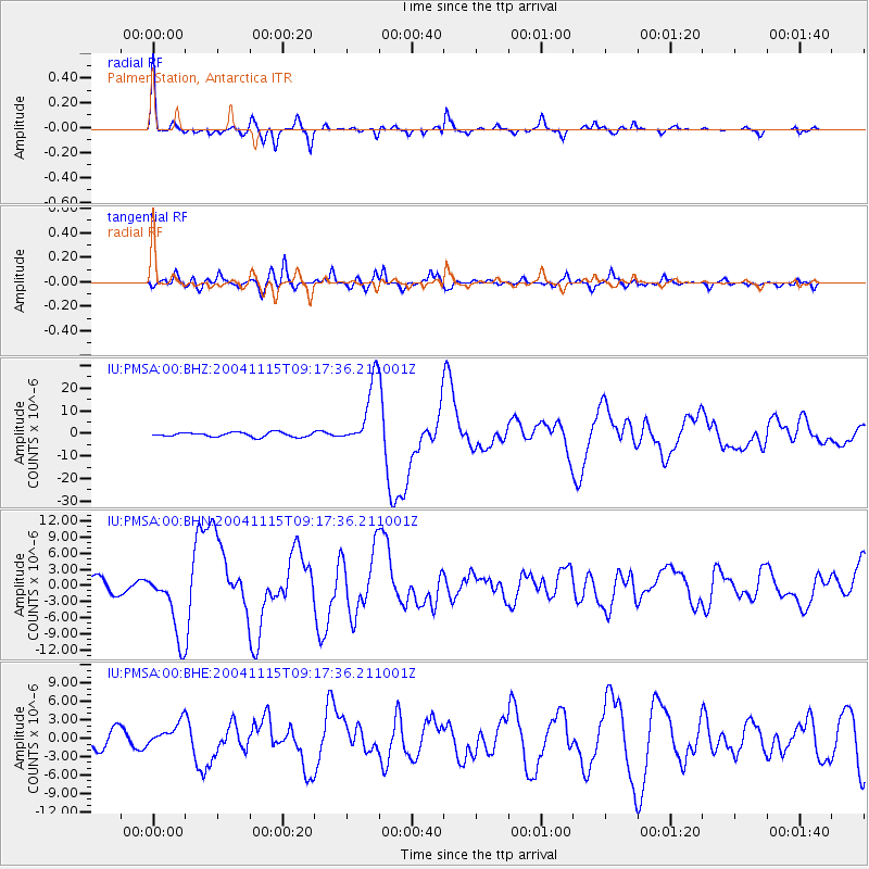
Earthquake location: Near West Coast Of Colombia
Earthquake latitude/longitude: 4.7/-77.5
Earthquake time(UTC): 2004/11/15 (320) 09:06:56 GMT
Earthquake Depth: 15 km
Earthquake Magnitude: 6.6 MB, 7.1 MS, 7.2 MW, 7.1 MW
Earthquake Catalog/Contributor: WHDF/NEIC
Network: IU Global Seismograph Network (GSN - IRIS/USGS)
Station: PMSA Palmer Station, Antarctica
Lat/Lon: 64.77 S/64.05 W
Elevation: 40 m
Distance: 70.0 deg
Az: 173.907 deg
Baz: 345.708 deg
Ray Param: 0.05525916
Estimated Moho Depth: 38.0 km
Estimated Crust Vp/Vs: 1.60
Assumed Crust Vp: 6.183 km/s
Estimated Crust Vs: 3.864 km/s
Estimated Crust Poisson's Ratio: 0.18
Radial Match: 91.693565 %
Radial Bump: 271
Transverse Match: 83.73447 %
Transverse Bump: 400
SOD ConfigId: 2459
Insert Time: 2010-03-04 15:25:57.362 +0000
GWidth: 2.5
Max Bumps: 400
Tol: 0.001

Signal To Noise

ChannelStoNSTALTA
IU:PMSA:00:BHN:20041115T09:17:36.211001Z5.0463026.280908E-61.2446556E-6
IU:PMSA:00:BHE:20041115T09:17:36.211001Z1.00917881.8890905E-61.8719088E-6
IU:PMSA:00:BHZ:20041115T09:17:36.211001Z15.0001131.4556982E-59.704582E-7
Arrivals
Ps3.8 SECOND
PpPs15 SECOND
PsPs/PpSs19 SECOND