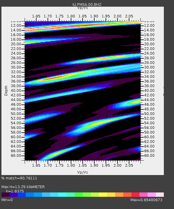
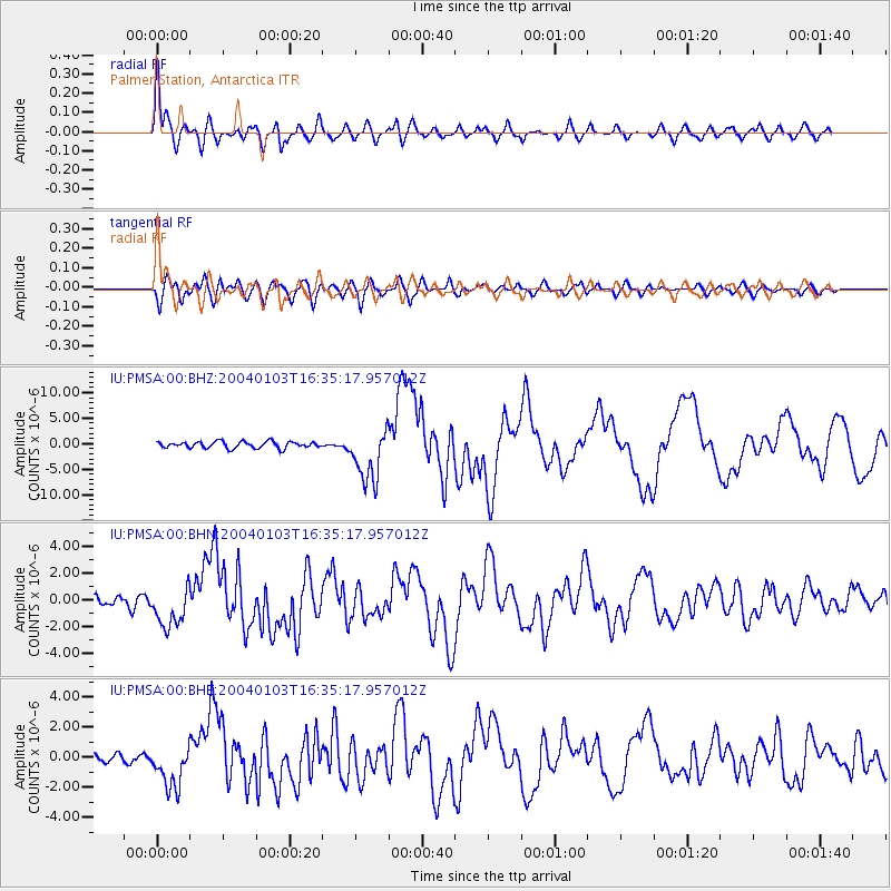
PMSA Palmer Station, Antarctica - Earthquake Result Viewer

Earthquake location: Southeast Of Loyalty Islands
Earthquake latitude/longitude: -22.3/169.7
Earthquake time(UTC): 2004/01/03 (003) 16:23:21 GMT
Earthquake Depth: 22 km
Earthquake Magnitude: 6.4 MB, 7.1 MS, 7.1 MW, 6.8 MW
Earthquake Catalog/Contributor: WHDF/NEIC
Network: IU Global Seismograph Network (GSN - IRIS/USGS)
Station: PMSA Palmer Station, Antarctica
Lat/Lon: 64.77 S/64.05 W
Elevation: 40 m
Distance: 84.0 deg
Az: 159.669 deg
Baz: 228.686 deg
Ray Param: 0.045799762
Estimated Moho Depth: 13.25 km
Estimated Crust Vp/Vs: 1.64
Assumed Crust Vp: 6.183 km/s
Estimated Crust Vs: 3.776 km/s
Estimated Crust Poisson's Ratio: 0.20
Radial Match: 90.76111 %
Radial Bump: 400
Transverse Match: 83.14505 %
Transverse Bump: 400
SOD ConfigId: 7314
Insert Time: 2010-03-04 15:26:05.117 +0000
GWidth: 2.5
Max Bumps: 400
Tol: 0.001

Signal To Noise

ChannelStoNSTALTA
IU:PMSA:00:BHN:20040103T16:35:17.957012Z3.82213381.5388222E-64.0260815E-7
IU:PMSA:00:BHE:20040103T16:35:17.957012Z3.41694971.5071718E-64.4108688E-7
IU:PMSA:00:BHZ:20040103T16:35:17.957012Z8.4037745.316316E-66.326105E-7
Arrivals
Ps1.4 SECOND
PpPs5.5 SECOND
PsPs/PpSs6.9 SECOND