You are here: Home > Network List > NN - Western Great Basin/Eastern Sierra Nevada Stations List
> Station GWY Greenwater Valley, CA. (GPS 12/06/2000) w84gm > Earthquake Result Viewer
GWY Greenwater Valley, CA. (GPS 12/06/2000) w84gm - Earthquake Result Viewer
| Earthquake location: |
Solomon Islands |
| Earthquake latitude/longitude: |
-9.3/157.9 |
| Earthquake time(UTC): |
2015/08/12 (224) 18:49:23 GMT |
| Earthquake Depth: |
5.0 km |
| Earthquake Magnitude: |
6.4 MWB, 6.8 MI, 6.9 MI |
| Earthquake Catalog/Contributor: |
NEIC PDE/NEIC COMCAT |
|
| Network: |
NN Western Great Basin/Eastern Sierra Nevada |
| Station: |
GWY Greenwater Valley, CA. (GPS 12/06/2000) w84gm |
| Lat/Lon: |
36.19 N/116.67 W |
| Elevation: |
1538 m |
|
| Distance: |
91.7 deg |
| Az: |
53.78 deg |
| Baz: |
259.817 deg |
| Ray Param: |
0.041564595 |
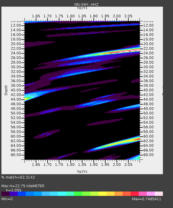
| Estimated Moho Depth: |
22.75 km |
| Estimated Crust Vp/Vs: |
2.06 |
| Assumed Crust Vp: |
6.279 km/s |
| Estimated Crust Vs: |
3.055 km/s |
| Estimated Crust Poisson's Ratio: |
0.34 |
|
| Radial Match: |
82.3142 % |
| Radial Bump: |
400 |
| Transverse Match: |
62.664375 % |
| Transverse Bump: |
400 |
| SOD ConfigId: |
7422571 |
| Insert Time: |
2019-04-20 08:36:47.416 +0000 |
| GWidth: |
2.5 |
| Max Bumps: |
400 |
| Tol: |
0.001 |
|

Signal To Noise
| Channel | StoN | STA | LTA |
| NN:GWY: :HHZ:20150812T19:02:00.677979Z | 1.4518411 | 1.5808499E-7 | 1.0888587E-7 |
| NN:GWY: :HHN:20150812T19:02:00.677979Z | 0.8477217 | 1.2736541E-7 | 1.5024436E-7 |
| NN:GWY: :HHE:20150812T19:02:00.677979Z | 0.7673217 | 1.14078794E-7 | 1.486714E-7 |
| Arrivals |
| Ps | 3.9 SECOND |
| PpPs | 11 SECOND |
| PsPs/PpSs | 15 SECOND |


