You are here: Home > Network List > IU - Global Seismograph Network (GSN - IRIS/USGS) Stations List
> Station PMSA Palmer Station, Antarctica > Earthquake Result Viewer
PMSA Palmer Station, Antarctica - Earthquake Result Viewer
| Earthquake location: |
Macquarie Island Region |
| Earthquake latitude/longitude: |
-55.7/158.5 |
| Earthquake time(UTC): |
2008/04/12 (103) 00:30:12 GMT |
| Earthquake Depth: |
16 km |
| Earthquake Magnitude: |
6.8 MB, 7.1 MS, 7.1 MW, 7.1 MW |
| Earthquake Catalog/Contributor: |
WHDF/NEIC |
|
| Network: |
IU Global Seismograph Network (GSN - IRIS/USGS) |
| Station: |
PMSA Palmer Station, Antarctica |
| Lat/Lon: |
64.77 S/64.05 W |
| Elevation: |
40 m |
|
| Distance: |
55.6 deg |
| Az: |
159.45 deg |
| Baz: |
207.656 deg |
| Ray Param: |
0.06469592 |
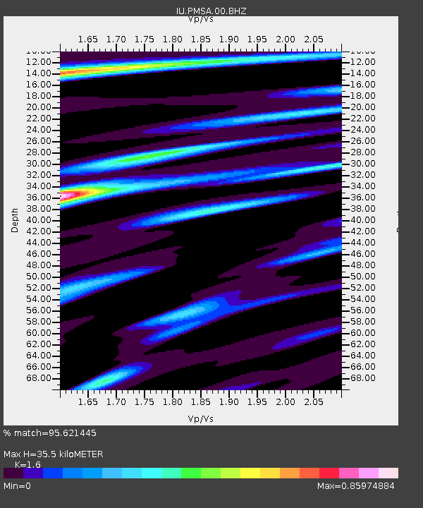
| Estimated Moho Depth: |
35.5 km |
| Estimated Crust Vp/Vs: |
1.60 |
| Assumed Crust Vp: |
6.183 km/s |
| Estimated Crust Vs: |
3.864 km/s |
| Estimated Crust Poisson's Ratio: |
0.18 |
|
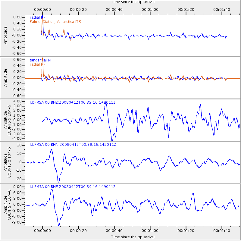
| Radial Match: |
95.621445 % |
| Radial Bump: |
341 |
| Transverse Match: |
82.178856 % |
| Transverse Bump: |
400 |
| SOD ConfigId: |
2504 |
| Insert Time: |
2010-03-04 15:26:17.784 +0000 |
| GWidth: |
2.5 |
| Max Bumps: |
400 |
| Tol: |
0.001 |
|
Signal To Noise
| Channel | StoN | STA | LTA |
| IU:PMSA:00:BHN:20080412T00:39:16.149011Z | 12.58097 | 5.561631E-6 | 4.4206698E-7 |
| IU:PMSA:00:BHE:20080412T00:39:16.149011Z | 8.107074 | 2.6085354E-6 | 3.217604E-7 |
| IU:PMSA:00:BHZ:20080412T00:39:16.149011Z | 3.0162244 | 9.291239E-7 | 3.0804205E-7 |
| Arrivals |
| Ps | 3.6 SECOND |
| PpPs | 14 SECOND |
| PsPs/PpSs | 18 SECOND |


