You are here: Home > Network List > TA - USArray Transportable Network (new EarthScope stations) Stations List
> Station H23K Yukon River, AK, USA > Earthquake Result Viewer
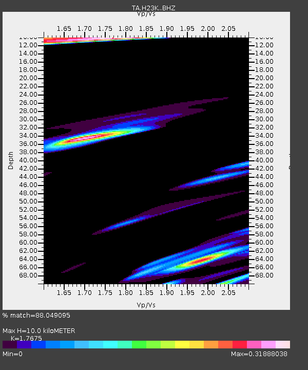
H23K Yukon River, AK, USA - Earthquake Result Viewer
| Earthquake location: |
Solomon Islands |
| Earthquake latitude/longitude: |
-9.3/157.9 |
| Earthquake time(UTC): |
2015/08/12 (224) 18:49:23 GMT |
| Earthquake Depth: |
5.0 km |
| Earthquake Magnitude: |
6.4 MWB, 6.8 MI, 6.9 MI |
| Earthquake Catalog/Contributor: |
NEIC PDE/NEIC COMCAT |
|
| Network: |
TA USArray Transportable Network (new EarthScope stations) |
| Station: |
H23K Yukon River, AK, USA |
| Lat/Lon: |
65.83 N/149.54 W |
| Elevation: |
617 m |
|
| Distance: |
84.2 deg |
| Az: |
19.177 deg |
| Baz: |
231.93 deg |
| Ray Param: |
0.04564511 |
| Estimated Moho Depth: |
10.0 km |
| Estimated Crust Vp/Vs: |
1.77 |
| Assumed Crust Vp: |
6.566 km/s |
| Estimated Crust Vs: |
3.715 km/s |
| Estimated Crust Poisson's Ratio: |
0.26 |
|
| Radial Match: |
88.049095 % |
| Radial Bump: |
372 |
| Transverse Match: |
68.86034 % |
| Transverse Bump: |
372 |
| SOD ConfigId: |
7422571 |
| Insert Time: |
2019-04-20 08:37:35.352 +0000 |
| GWidth: |
2.5 |
| Max Bumps: |
400 |
| Tol: |
0.001 |
|

Signal To Noise
| Channel | StoN | STA | LTA |
| TA:H23K: :BHZ:20150812T19:01:24.400024Z | 2.8531501 | 6.175118E-7 | 2.1643157E-7 |
| TA:H23K: :BHN:20150812T19:01:24.400024Z | 1.1128465 | 2.3374955E-7 | 2.1004654E-7 |
| TA:H23K: :BHE:20150812T19:01:24.400024Z | 1.1624948 | 2.7871081E-7 | 2.397523E-7 |
| Arrivals |
| Ps | 1.2 SECOND |
| PpPs | 4.1 SECOND |
| PsPs/PpSs | 5.3 SECOND |


