You are here: Home > Network List > TA - USArray Transportable Network (new EarthScope stations) Stations List
> Station L04D Klamath Falls, OR, USA > Earthquake Result Viewer
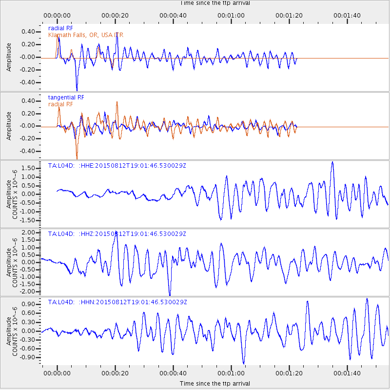
L04D Klamath Falls, OR, USA - Earthquake Result Viewer
*The percent match for this event was below the threshold and hence no stack was calculated.
| Earthquake location: |
Solomon Islands |
| Earthquake latitude/longitude: |
-9.3/157.9 |
| Earthquake time(UTC): |
2015/08/12 (224) 18:49:23 GMT |
| Earthquake Depth: |
5.0 km |
| Earthquake Magnitude: |
6.4 MWB, 6.8 MI, 6.9 MI |
| Earthquake Catalog/Contributor: |
NEIC PDE/NEIC COMCAT |
|
| Network: |
TA USArray Transportable Network (new EarthScope stations) |
| Station: |
L04D Klamath Falls, OR, USA |
| Lat/Lon: |
42.22 N/122.30 W |
| Elevation: |
1437 m |
|
| Distance: |
88.7 deg |
| Az: |
46.987 deg |
| Baz: |
256.29 deg |
| Ray Param: |
$rayparam |
*The percent match for this event was below the threshold and hence was not used in the summary stack. |
|
| Radial Match: |
86.934235 % |
| Radial Bump: |
400 |
| Transverse Match: |
80.55474 % |
| Transverse Bump: |
352 |
| SOD ConfigId: |
7422571 |
| Insert Time: |
2019-04-20 08:37:40.983 +0000 |
| GWidth: |
2.5 |
| Max Bumps: |
400 |
| Tol: |
0.001 |
|
Signal To Noise
| Channel | StoN | STA | LTA |
| TA:L04D: :HHZ:20150812T19:01:46.530029Z | 1.8616979 | 2.910738E-7 | 1.5634858E-7 |
| TA:L04D: :HHN:20150812T19:01:46.530029Z | 0.49545217 | 7.404847E-8 | 1.4945634E-7 |
| TA:L04D: :HHE:20150812T19:01:46.530029Z | 2.5085008 | 3.294035E-7 | 1.3131488E-7 |
| Arrivals |
| Ps | |
| PpPs | |
| PsPs/PpSs | |


