You are here: Home > Network List > TJ - Tajikistan National Seismic Network Stations List
> Station GARM Garm, Tajikistan > Earthquake Result Viewer
GARM Garm, Tajikistan - Earthquake Result Viewer
| Earthquake location: |
Solomon Islands |
| Earthquake latitude/longitude: |
-9.3/157.9 |
| Earthquake time(UTC): |
2015/08/12 (224) 18:49:23 GMT |
| Earthquake Depth: |
5.0 km |
| Earthquake Magnitude: |
6.4 MWB, 6.8 MI, 6.9 MI |
| Earthquake Catalog/Contributor: |
NEIC PDE/NEIC COMCAT |
|
| Network: |
TJ Tajikistan National Seismic Network |
| Station: |
GARM Garm, Tajikistan |
| Lat/Lon: |
39.00 N/70.32 E |
| Elevation: |
1305 m |
|
| Distance: |
93.9 deg |
| Az: |
308.704 deg |
| Baz: |
98.71 deg |
| Ray Param: |
0.04115925 |
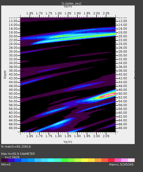
| Estimated Moho Depth: |
50.5 km |
| Estimated Crust Vp/Vs: |
2.06 |
| Assumed Crust Vp: |
6.306 km/s |
| Estimated Crust Vs: |
3.057 km/s |
| Estimated Crust Poisson's Ratio: |
0.35 |
|
| Radial Match: |
85.20916 % |
| Radial Bump: |
400 |
| Transverse Match: |
78.0174 % |
| Transverse Bump: |
400 |
| SOD ConfigId: |
7422571 |
| Insert Time: |
2019-04-20 08:37:56.313 +0000 |
| GWidth: |
2.5 |
| Max Bumps: |
400 |
| Tol: |
0.001 |
|
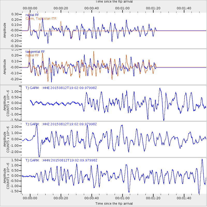
Signal To Noise
| Channel | StoN | STA | LTA |
| TJ:GARM: :HHZ:20150812T19:02:09.97998Z | 9.349579 | 9.88769E-7 | 1.0575545E-7 |
| TJ:GARM: :HHN:20150812T19:02:09.97998Z | 1.335478 | 1.09946754E-7 | 8.2327645E-8 |
| TJ:GARM: :HHE:20150812T19:02:09.97998Z | 3.169056 | 2.6872635E-7 | 8.479698E-8 |
| Arrivals |
| Ps | 8.7 SECOND |
| PpPs | 24 SECOND |
| PsPs/PpSs | 33 SECOND |


