You are here: Home > Network List > TJ - Tajikistan National Seismic Network Stations List
> Station SHAA Shaartuz, Tajikistan > Earthquake Result Viewer
SHAA Shaartuz, Tajikistan - Earthquake Result Viewer

| Earthquake location: |
Solomon Islands |
| Earthquake latitude/longitude: |
-9.3/157.9 |
| Earthquake time(UTC): |
2015/08/12 (224) 18:49:23 GMT |
| Earthquake Depth: |
5.0 km |
| Earthquake Magnitude: |
6.4 MWB, 6.8 MI, 6.9 MI |
| Earthquake Catalog/Contributor: |
NEIC PDE/NEIC COMCAT |
|
| Network: |
TJ Tajikistan National Seismic Network |
| Station: |
SHAA Shaartuz, Tajikistan |
| Lat/Lon: |
37.56 N/68.12 E |
| Elevation: |
868 m |
|
| Distance: |
95.5 deg |
| Az: |
307.034 deg |
| Baz: |
97.494 deg |
| Ray Param: |
0.040780567 |
| Estimated Moho Depth: |
45.0 km |
| Estimated Crust Vp/Vs: |
1.77 |
| Assumed Crust Vp: |
6.213 km/s |
| Estimated Crust Vs: |
3.501 km/s |
| Estimated Crust Poisson's Ratio: |
0.27 |
|
| Radial Match: |
81.831795 % |
| Radial Bump: |
400 |
| Transverse Match: |
76.268 % |
| Transverse Bump: |
400 |
| SOD ConfigId: |
7422571 |
| Insert Time: |
2019-04-20 08:37:57.143 +0000 |
| GWidth: |
2.5 |
| Max Bumps: |
400 |
| Tol: |
0.001 |
|
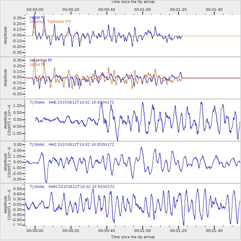
Signal To Noise
| Channel | StoN | STA | LTA |
| TJ:SHAA: :HHZ:20150812T19:02:16.830017Z | 5.0267487 | 7.980841E-7 | 1.5876746E-7 |
| TJ:SHAA: :HHN:20150812T19:02:16.830017Z | 1.1789179 | 1.3385183E-7 | 1.13537865E-7 |
| TJ:SHAA: :HHE:20150812T19:02:16.830017Z | 1.1856415 | 1.5426929E-7 | 1.301146E-7 |
| Arrivals |
| Ps | 5.7 SECOND |
| PpPs | 20 SECOND |
| PsPs/PpSs | 25 SECOND |


