You are here: Home > Network List > UU - University of Utah Regional Network Stations List
> Station SZCU Shurtz Canyon, UT, USA > Earthquake Result Viewer
SZCU Shurtz Canyon, UT, USA - Earthquake Result Viewer
| Earthquake location: |
Solomon Islands |
| Earthquake latitude/longitude: |
-9.3/157.9 |
| Earthquake time(UTC): |
2015/08/12 (224) 18:49:23 GMT |
| Earthquake Depth: |
5.0 km |
| Earthquake Magnitude: |
6.4 MWB, 6.8 MI, 6.9 MI |
| Earthquake Catalog/Contributor: |
NEIC PDE/NEIC COMCAT |
|
| Network: |
UU University of Utah Regional Network |
| Station: |
SZCU Shurtz Canyon, UT, USA |
| Lat/Lon: |
37.60 N/113.09 W |
| Elevation: |
2026 m |
|
| Distance: |
94.8 deg |
| Az: |
52.843 deg |
| Baz: |
262.012 deg |
| Ray Param: |
0.040953353 |
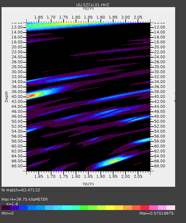
| Estimated Moho Depth: |
39.75 km |
| Estimated Crust Vp/Vs: |
1.60 |
| Assumed Crust Vp: |
6.194 km/s |
| Estimated Crust Vs: |
3.871 km/s |
| Estimated Crust Poisson's Ratio: |
0.18 |
|
| Radial Match: |
83.47132 % |
| Radial Bump: |
400 |
| Transverse Match: |
72.692604 % |
| Transverse Bump: |
338 |
| SOD ConfigId: |
7422571 |
| Insert Time: |
2019-04-20 08:38:29.461 +0000 |
| GWidth: |
2.5 |
| Max Bumps: |
400 |
| Tol: |
0.001 |
|

Signal To Noise
| Channel | StoN | STA | LTA |
| UU:SZCU:01:HHZ:20150812T19:02:14.679993Z | 2.1360254 | 3.911962E-9 | 1.8314209E-9 |
| UU:SZCU:01:HHN:20150812T19:02:14.679993Z | 0.94448876 | 3.0132399E-9 | 3.1903398E-9 |
| UU:SZCU:01:HHE:20150812T19:02:14.679993Z | 1.3245656 | 2.0807585E-9 | 1.5708986E-9 |
| Arrivals |
| Ps | 3.9 SECOND |
| PpPs | 16 SECOND |
| PsPs/PpSs | 20 SECOND |


