PMSA Palmer Station, Antarctica - Earthquake Result Viewer
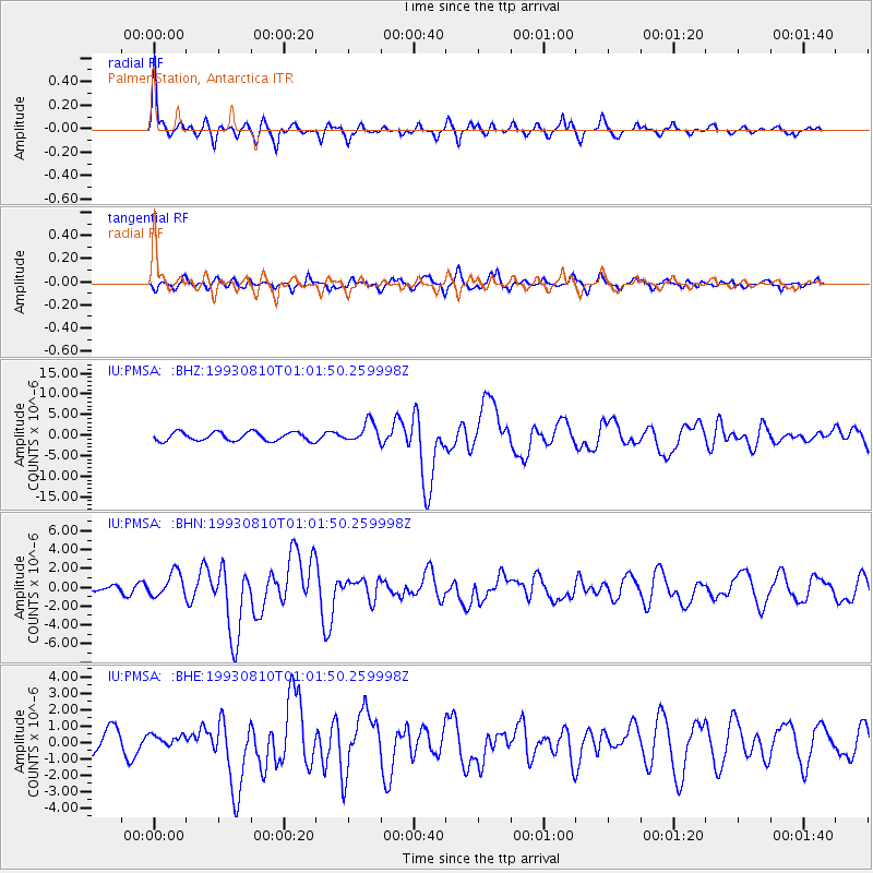
Earthquake location: Off W. Coast Of S. Island, N.Z.
Earthquake latitude/longitude: -45.1/167.0
Earthquake time(UTC): 1993/08/10 (222) 00:51:54 GMT
Earthquake Depth: 33 km
Earthquake Magnitude: 6.2 MB, 7.1 MS, 7.1 UNKNOWN, 7.0 MW
Earthquake Catalog/Contributor: WHDF/NEIC
Network: IU Global Seismograph Network (GSN - IRIS/USGS)
Station: PMSA Palmer Station, Antarctica
Lat/Lon: 64.77 S/64.05 W
Elevation: 40 m
Distance: 63.4 deg
Az: 158.136 deg
Baz: 217.956 deg
Ray Param: 0.059535142
Estimated Moho Depth: 45.75 km
Estimated Crust Vp/Vs: 2.06
Assumed Crust Vp: 6.183 km/s
Estimated Crust Vs: 3.005 km/s
Estimated Crust Poisson's Ratio: 0.35
Radial Match: 88.702866 %
Radial Bump: 400
Transverse Match: 62.605267 %
Transverse Bump: 400
SOD ConfigId: 16938
Insert Time: 2010-03-04 15:26:27.705 +0000
GWidth: 2.5
Max Bumps: 400
Tol: 0.001

Signal To Noise

ChannelStoNSTALTA
IU:PMSA: :BHN:19930810T01:01:50.259998Z2.43639871.2540858E-65.1472927E-7
IU:PMSA: :BHE:19930810T01:01:50.259998Z0.274437813.0930786E-71.1270599E-6
IU:PMSA: :BHZ:19930810T01:01:50.259998Z2.37335782.46026E-61.0366158E-6
Arrivals
Ps8.1 SECOND
PpPs22 SECOND
PsPs/PpSs30 SECOND