You are here: Home > Network List > IU - Global Seismograph Network (GSN - IRIS/USGS) Stations List
> Station PMSA Palmer Station, Antarctica > Earthquake Result Viewer
PMSA Palmer Station, Antarctica - Earthquake Result Viewer
| Earthquake location: |
Vanuatu Islands |
| Earthquake latitude/longitude: |
-18.8/169.2 |
| Earthquake time(UTC): |
1994/02/11 (042) 21:17:31 GMT |
| Earthquake Depth: |
204 km |
| Earthquake Magnitude: |
6.3 MB, 7.0 UNKNOWN, 6.8 MW |
| Earthquake Catalog/Contributor: |
WHDF/NEIC |
|
| Network: |
IU Global Seismograph Network (GSN - IRIS/USGS) |
| Station: |
PMSA Palmer Station, Antarctica |
| Lat/Lon: |
64.77 S/64.05 W |
| Elevation: |
40 m |
|
| Distance: |
87.3 deg |
| Az: |
159.906 deg |
| Baz: |
229.413 deg |
| Ray Param: |
0.04292303 |
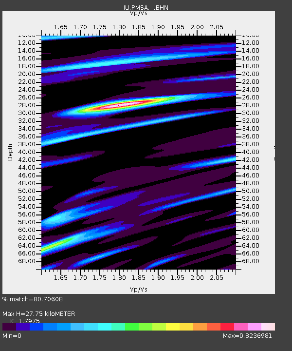
| Estimated Moho Depth: |
27.75 km |
| Estimated Crust Vp/Vs: |
1.80 |
| Assumed Crust Vp: |
6.183 km/s |
| Estimated Crust Vs: |
3.44 km/s |
| Estimated Crust Poisson's Ratio: |
0.28 |
|
| Radial Match: |
80.70608 % |
| Radial Bump: |
400 |
| Transverse Match: |
71.328674 % |
| Transverse Bump: |
400 |
| SOD ConfigId: |
16938 |
| Insert Time: |
2010-03-04 15:26:30.718 +0000 |
| GWidth: |
2.5 |
| Max Bumps: |
400 |
| Tol: |
0.001 |
|

Signal To Noise
| Channel | StoN | STA | LTA |
| IU:PMSA: :BHN:19940211T21:29:23.960022Z | 2.3135808 | 2.0423392E-6 | 8.827612E-7 |
| IU:PMSA: :BHE:19940211T21:29:23.960022Z | 2.404953 | 1.9442996E-6 | 8.0845643E-7 |
| IU:PMSA: :BHZ:19940211T21:29:23.960022Z | 7.9791 | 8.041691E-6 | 1.0078444E-6 |
| Arrivals |
| Ps | 3.7 SECOND |
| PpPs | 12 SECOND |
| PsPs/PpSs | 16 SECOND |


