You are here: Home > Network List > XD14 - Illuminating the architecture of the greater Mount St. Helens magmatic systems f Stations List
> Station MO07 "Mount St Helens, WA" > Earthquake Result Viewer
MO07 "Mount St Helens, WA" - Earthquake Result Viewer
| Earthquake location: |
Solomon Islands |
| Earthquake latitude/longitude: |
-9.3/157.9 |
| Earthquake time(UTC): |
2015/08/12 (224) 18:49:23 GMT |
| Earthquake Depth: |
5.0 km |
| Earthquake Magnitude: |
6.4 MWB, 6.8 MI, 6.9 MI |
| Earthquake Catalog/Contributor: |
NEIC PDE/NEIC COMCAT |
|
| Network: |
XD Illuminating the architecture of the greater Mount St. Helens magmatic systems f |
| Station: |
MO07 "Mount St Helens, WA" |
| Lat/Lon: |
45.89 N/122.08 W |
| Elevation: |
1248 m |
|
| Distance: |
89.7 deg |
| Az: |
43.461 deg |
| Baz: |
256.394 deg |
| Ray Param: |
0.041725032 |
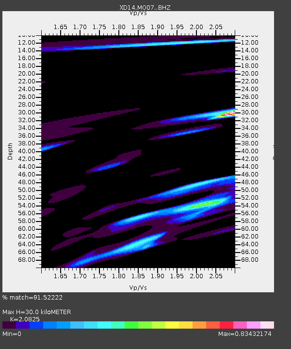
| Estimated Moho Depth: |
30.0 km |
| Estimated Crust Vp/Vs: |
2.08 |
| Assumed Crust Vp: |
6.566 km/s |
| Estimated Crust Vs: |
3.153 km/s |
| Estimated Crust Poisson's Ratio: |
0.35 |
|
| Radial Match: |
91.52222 % |
| Radial Bump: |
400 |
| Transverse Match: |
62.973843 % |
| Transverse Bump: |
400 |
| SOD ConfigId: |
7422571 |
| Insert Time: |
2019-04-20 08:38:56.131 +0000 |
| GWidth: |
2.5 |
| Max Bumps: |
400 |
| Tol: |
0.001 |
|

Signal To Noise
| Channel | StoN | STA | LTA |
| XD:MO07: :BHZ:20150812T19:01:51.27002Z | 1.2280991 | 2.3457586E-7 | 1.9100729E-7 |
| XD:MO07: :BHN:20150812T19:01:51.27002Z | 2.028598 | 1.9238192E-7 | 9.483492E-8 |
| XD:MO07: :BHE:20150812T19:01:51.27002Z | 0.7710351 | 1.5666757E-7 | 2.0319122E-7 |
| Arrivals |
| Ps | 5.0 SECOND |
| PpPs | 14 SECOND |
| PsPs/PpSs | 19 SECOND |


