You are here: Home > Network List > IU - Global Seismograph Network (GSN - IRIS/USGS) Stations List
> Station PMSA Palmer Station, Antarctica > Earthquake Result Viewer
PMSA Palmer Station, Antarctica - Earthquake Result Viewer
| Earthquake location: |
Vanuatu Islands |
| Earthquake latitude/longitude: |
-17.8/167.6 |
| Earthquake time(UTC): |
1994/10/01 (274) 16:35:22 GMT |
| Earthquake Depth: |
33 km |
| Earthquake Magnitude: |
5.7 MB, 6.5 MS, 6.5 UNKNOWN, 6.5 MW |
| Earthquake Catalog/Contributor: |
WHDF/NEIC |
|
| Network: |
IU Global Seismograph Network (GSN - IRIS/USGS) |
| Station: |
PMSA Palmer Station, Antarctica |
| Lat/Lon: |
64.77 S/64.05 W |
| Elevation: |
40 m |
|
| Distance: |
88.8 deg |
| Az: |
160.349 deg |
| Baz: |
228.405 deg |
| Ray Param: |
0.04226006 |
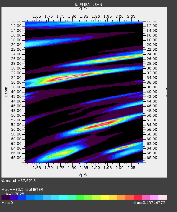
| Estimated Moho Depth: |
33.5 km |
| Estimated Crust Vp/Vs: |
1.78 |
| Assumed Crust Vp: |
6.183 km/s |
| Estimated Crust Vs: |
3.469 km/s |
| Estimated Crust Poisson's Ratio: |
0.27 |
|
| Radial Match: |
87.6213 % |
| Radial Bump: |
376 |
| Transverse Match: |
66.97328 % |
| Transverse Bump: |
400 |
| SOD ConfigId: |
17000 |
| Insert Time: |
2010-03-04 15:26:38.920 +0000 |
| GWidth: |
2.5 |
| Max Bumps: |
400 |
| Tol: |
0.001 |
|

Signal To Noise
| Channel | StoN | STA | LTA |
| IU:PMSA: :BHN:19941001T16:47:42.166028Z | 1.6939478 | 3.221337E-7 | 1.9016744E-7 |
| IU:PMSA: :BHE:19941001T16:47:42.166028Z | 1.6064047 | 2.3767447E-7 | 1.479543E-7 |
| IU:PMSA: :BHZ:19941001T16:47:42.166028Z | 5.0384345 | 9.197211E-7 | 1.8254106E-7 |
| Arrivals |
| Ps | 4.3 SECOND |
| PpPs | 15 SECOND |
| PsPs/PpSs | 19 SECOND |


