You are here: Home > Network List > XL12 - Hangay Dome, Mongolia Stations List
> Station HV17 HV17 > Earthquake Result Viewer
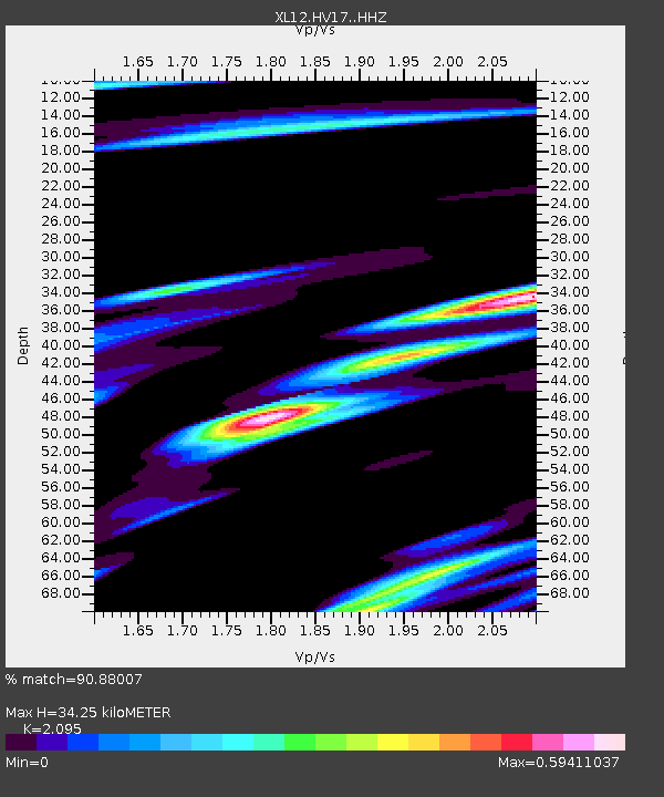
HV17 HV17 - Earthquake Result Viewer
| Earthquake location: |
Solomon Islands |
| Earthquake latitude/longitude: |
-9.3/157.9 |
| Earthquake time(UTC): |
2015/08/12 (224) 18:49:23 GMT |
| Earthquake Depth: |
5.0 km |
| Earthquake Magnitude: |
6.4 MWB, 6.8 MI, 6.9 MI |
| Earthquake Catalog/Contributor: |
NEIC PDE/NEIC COMCAT |
|
| Network: |
XL Hangay Dome, Mongolia |
| Station: |
HV17 HV17 |
| Lat/Lon: |
50.54 N/100.40 E |
| Elevation: |
1692 m |
|
| Distance: |
77.6 deg |
| Az: |
326.55 deg |
| Baz: |
121.513 deg |
| Ray Param: |
0.050200965 |
| Estimated Moho Depth: |
34.25 km |
| Estimated Crust Vp/Vs: |
2.10 |
| Assumed Crust Vp: |
6.419 km/s |
| Estimated Crust Vs: |
3.064 km/s |
| Estimated Crust Poisson's Ratio: |
0.35 |
|
| Radial Match: |
90.88007 % |
| Radial Bump: |
400 |
| Transverse Match: |
91.642555 % |
| Transverse Bump: |
400 |
| SOD ConfigId: |
7422571 |
| Insert Time: |
2019-04-20 08:39:23.244 +0000 |
| GWidth: |
2.5 |
| Max Bumps: |
400 |
| Tol: |
0.001 |
|

Signal To Noise
| Channel | StoN | STA | LTA |
| XL:HV17: :HHZ:20150812T19:00:48.849976Z | 3.9940476 | 1.0178425E-6 | 2.5483985E-7 |
| XL:HV17: :HHN:20150812T19:00:48.849976Z | 1.7811272 | 1.8839965E-7 | 1.0577552E-7 |
| XL:HV17: :HHE:20150812T19:00:48.849976Z | 1.884762 | 3.5321256E-7 | 1.8740431E-7 |
| Arrivals |
| Ps | 6.0 SECOND |
| PpPs | 16 SECOND |
| PsPs/PpSs | 22 SECOND |


