PMSA Palmer Station, Antarctica - Earthquake Result Viewer
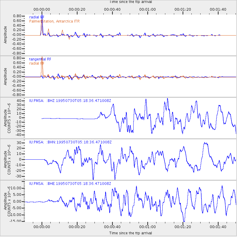
Earthquake location: Near Coast Of Northern Chile
Earthquake latitude/longitude: -23.4/-70.3
Earthquake time(UTC): 1995/07/30 (211) 05:11:23 GMT
Earthquake Depth: 47 km
Earthquake Magnitude: 6.6 MB, 7.3 MS, 7.2 UNKNOWN, 8.1 MW
Earthquake Catalog/Contributor: WHDF/NEIC
Network: IU Global Seismograph Network (GSN - IRIS/USGS)
Station: PMSA Palmer Station, Antarctica
Lat/Lon: 64.77 S/64.05 W
Elevation: 40 m
Distance: 41.6 deg
Az: 175.963 deg
Baz: 351.316 deg
Ray Param: 0.07356126
Estimated Moho Depth: 29.75 km
Estimated Crust Vp/Vs: 1.71
Assumed Crust Vp: 6.183 km/s
Estimated Crust Vs: 3.626 km/s
Estimated Crust Poisson's Ratio: 0.24
Radial Match: 97.60278 %
Radial Bump: 316
Transverse Match: 88.67018 %
Transverse Bump: 400
SOD ConfigId: 6273
Insert Time: 2010-03-04 15:26:40.507 +0000
GWidth: 2.5
Max Bumps: 400
Tol: 0.001

Signal To Noise

ChannelStoNSTALTA
IU:PMSA: :BHN:19950730T05:18:36.471008Z15.5230084.2098E-62.7119742E-7
IU:PMSA: :BHE:19950730T05:18:36.471008Z5.69017746.278643E-71.1034178E-7
IU:PMSA: :BHZ:19950730T05:18:36.471008Z19.9183436.5837303E-63.3053604E-7
Arrivals
Ps3.6 SECOND
PpPs12 SECOND
PsPs/PpSs16 SECOND