You are here: Home > Network List > IU - Global Seismograph Network (GSN - IRIS/USGS) Stations List
> Station PMSA Palmer Station, Antarctica > Earthquake Result Viewer
PMSA Palmer Station, Antarctica - Earthquake Result Viewer
| Earthquake location: |
Pacific-Antarctic Ridge |
| Earthquake latitude/longitude: |
-56.8/-141.7 |
| Earthquake time(UTC): |
1995/08/23 (235) 13:14:42 GMT |
| Earthquake Depth: |
10 km |
| Earthquake Magnitude: |
5.9 MB, 5.6 MS, 5.5 UNKNOWN, 6.2 MW |
| Earthquake Catalog/Contributor: |
WHDF/NEIC |
|
| Network: |
IU Global Seismograph Network (GSN - IRIS/USGS) |
| Station: |
PMSA Palmer Station, Antarctica |
| Lat/Lon: |
64.77 S/64.05 W |
| Elevation: |
40 m |
|
| Distance: |
36.4 deg |
| Az: |
135.17 deg |
| Baz: |
244.992 deg |
| Ray Param: |
0.076689556 |
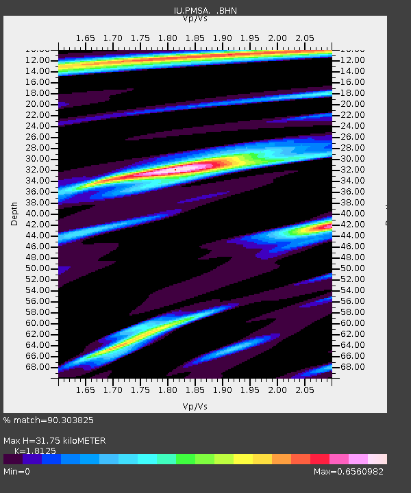
| Estimated Moho Depth: |
31.75 km |
| Estimated Crust Vp/Vs: |
1.81 |
| Assumed Crust Vp: |
6.183 km/s |
| Estimated Crust Vs: |
3.411 km/s |
| Estimated Crust Poisson's Ratio: |
0.28 |
|
| Radial Match: |
90.303825 % |
| Radial Bump: |
263 |
| Transverse Match: |
62.377407 % |
| Transverse Bump: |
400 |
| SOD ConfigId: |
6273 |
| Insert Time: |
2010-03-04 15:26:52.499 +0000 |
| GWidth: |
2.5 |
| Max Bumps: |
400 |
| Tol: |
0.001 |
|
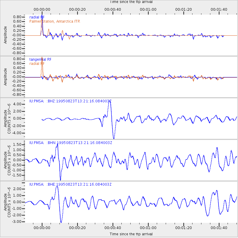
Signal To Noise
| Channel | StoN | STA | LTA |
| IU:PMSA: :BHN:19950823T13:21:16.084003Z | 0.8246729 | 1.9529384E-7 | 2.368137E-7 |
| IU:PMSA: :BHE:19950823T13:21:16.084003Z | 2.5858722 | 3.719467E-7 | 1.4383801E-7 |
| IU:PMSA: :BHZ:19950823T13:21:16.084003Z | 4.00345 | 7.108819E-7 | 1.7756734E-7 |
| Arrivals |
| Ps | 4.5 SECOND |
| PpPs | 14 SECOND |
| PsPs/PpSs | 18 SECOND |


