You are here: Home > Network List > IU - Global Seismograph Network (GSN - IRIS/USGS) Stations List
> Station PMSA Palmer Station, Antarctica > Earthquake Result Viewer
PMSA Palmer Station, Antarctica - Earthquake Result Viewer

| Earthquake location: |
Santa Cruz Islands |
| Earthquake latitude/longitude: |
-12.9/166.5 |
| Earthquake time(UTC): |
1997/04/21 (111) 12:06:34 GMT |
| Earthquake Depth: |
33 km |
| Earthquake Magnitude: |
6.1 MB |
| Earthquake Catalog/Contributor: |
WHDF/NEIC |
|
| Network: |
IU Global Seismograph Network (GSN - IRIS/USGS) |
| Station: |
PMSA Palmer Station, Antarctica |
| Lat/Lon: |
64.77 S/64.05 W |
| Elevation: |
40 m |
|
| Distance: |
93.8 deg |
| Az: |
160.644 deg |
| Baz: |
228.957 deg |
| Ray Param: |
0.041185956 |
| Estimated Moho Depth: |
10.0 km |
| Estimated Crust Vp/Vs: |
1.95 |
| Assumed Crust Vp: |
6.183 km/s |
| Estimated Crust Vs: |
3.175 km/s |
| Estimated Crust Poisson's Ratio: |
0.32 |
|
| Radial Match: |
85.981804 % |
| Radial Bump: |
365 |
| Transverse Match: |
68.41363 % |
| Transverse Bump: |
400 |
| SOD ConfigId: |
6273 |
| Insert Time: |
2010-03-04 15:26:58.861 +0000 |
| GWidth: |
2.5 |
| Max Bumps: |
400 |
| Tol: |
0.001 |
|
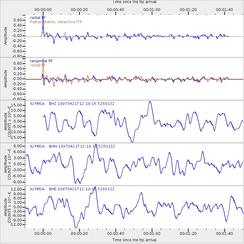
Signal To Noise
| Channel | StoN | STA | LTA |
| IU:PMSA: :BHN:19970421T12:19:16.526013Z | 0.6099594 | 1.9263116E-6 | 3.1580978E-6 |
| IU:PMSA: :BHE:19970421T12:19:16.526013Z | 2.126948 | 5.268877E-6 | 2.4772005E-6 |
| IU:PMSA: :BHZ:19970421T12:19:16.526013Z | 1.5254381 | 8.9511095E-6 | 5.8678947E-6 |
| Arrivals |
| Ps | 1.6 SECOND |
| PpPs | 4.7 SECOND |
| PsPs/PpSs | 6.2 SECOND |


