You are here: Home > Network List > ZJ12 - Transantarctic Mountains Northern Network Stations List
> Station MICH Tinker Glacier, Antarctica > Earthquake Result Viewer
MICH Tinker Glacier, Antarctica - Earthquake Result Viewer
| Earthquake location: |
Solomon Islands |
| Earthquake latitude/longitude: |
-9.3/157.9 |
| Earthquake time(UTC): |
2015/08/12 (224) 18:49:23 GMT |
| Earthquake Depth: |
5.0 km |
| Earthquake Magnitude: |
6.4 MWB, 6.8 MI, 6.9 MI |
| Earthquake Catalog/Contributor: |
NEIC PDE/NEIC COMCAT |
|
| Network: |
ZJ Transantarctic Mountains Northern Network |
| Station: |
MICH Tinker Glacier, Antarctica |
| Lat/Lon: |
73.82 S/164.10 E |
| Elevation: |
817 m |
|
| Distance: |
64.6 deg |
| Az: |
178.088 deg |
| Baz: |
353.258 deg |
| Ray Param: |
0.05885608 |
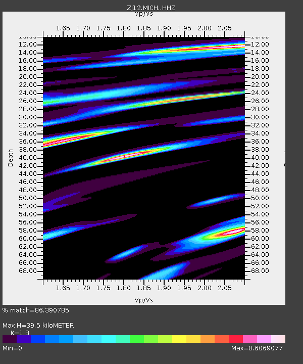
| Estimated Moho Depth: |
39.5 km |
| Estimated Crust Vp/Vs: |
1.80 |
| Assumed Crust Vp: |
6.245 km/s |
| Estimated Crust Vs: |
3.469 km/s |
| Estimated Crust Poisson's Ratio: |
0.28 |
|
| Radial Match: |
86.390785 % |
| Radial Bump: |
359 |
| Transverse Match: |
77.419495 % |
| Transverse Bump: |
400 |
| SOD ConfigId: |
7422571 |
| Insert Time: |
2019-04-20 08:40:31.000 +0000 |
| GWidth: |
2.5 |
| Max Bumps: |
400 |
| Tol: |
0.001 |
|

Signal To Noise
| Channel | StoN | STA | LTA |
| ZJ:MICH: :HHZ:20150812T18:59:30.328979Z | 2.6649663 | 4.7518714E-7 | 1.7830887E-7 |
| ZJ:MICH: :HHN:20150812T18:59:30.328979Z | 2.2054772 | 2.7037453E-7 | 1.2259231E-7 |
| ZJ:MICH: :HHE:20150812T18:59:30.328979Z | 0.9888683 | 1.4209701E-7 | 1.436966E-7 |
| Arrivals |
| Ps | 5.3 SECOND |
| PpPs | 17 SECOND |
| PsPs/PpSs | 22 SECOND |


