You are here: Home > Network List > IU - Global Seismograph Network (GSN - IRIS/USGS) Stations List
> Station PMSA Palmer Station, Antarctica > Earthquake Result Viewer
PMSA Palmer Station, Antarctica - Earthquake Result Viewer
| Earthquake location: |
Kermadec Islands Region |
| Earthquake latitude/longitude: |
-28.7/-177.6 |
| Earthquake time(UTC): |
1997/09/20 (263) 16:11:32 GMT |
| Earthquake Depth: |
30 km |
| Earthquake Magnitude: |
6.1 MB, 7.0 MS, 7.2 UNKNOWN, 6.7 ME |
| Earthquake Catalog/Contributor: |
WHDF/NEIC |
|
| Network: |
IU Global Seismograph Network (GSN - IRIS/USGS) |
| Station: |
PMSA Palmer Station, Antarctica |
| Lat/Lon: |
64.77 S/64.05 W |
| Elevation: |
40 m |
|
| Distance: |
73.7 deg |
| Az: |
155.843 deg |
| Baz: |
237.042 deg |
| Ray Param: |
0.05279439 |
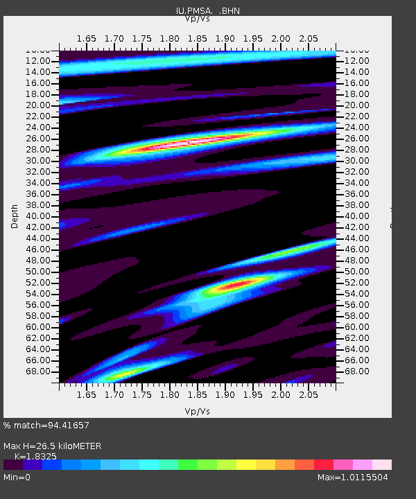
| Estimated Moho Depth: |
26.5 km |
| Estimated Crust Vp/Vs: |
1.83 |
| Assumed Crust Vp: |
6.183 km/s |
| Estimated Crust Vs: |
3.374 km/s |
| Estimated Crust Poisson's Ratio: |
0.29 |
|
| Radial Match: |
94.41657 % |
| Radial Bump: |
400 |
| Transverse Match: |
84.59533 % |
| Transverse Bump: |
400 |
| SOD ConfigId: |
6273 |
| Insert Time: |
2010-03-04 15:27:08.566 +0000 |
| GWidth: |
2.5 |
| Max Bumps: |
400 |
| Tol: |
0.001 |
|

Signal To Noise
| Channel | StoN | STA | LTA |
| IU:PMSA: :BHN:19970920T16:22:31.915002Z | 6.5632524 | 1.0389998E-6 | 1.5830564E-7 |
| IU:PMSA: :BHE:19970920T16:22:31.915002Z | 7.659267 | 1.6908242E-6 | 2.2075537E-7 |
| IU:PMSA: :BHZ:19970920T16:22:31.915002Z | 19.9074 | 3.871318E-6 | 1.9446627E-7 |
| Arrivals |
| Ps | 3.7 SECOND |
| PpPs | 12 SECOND |
| PsPs/PpSs | 15 SECOND |


