You are here: Home > Network List > IU - Global Seismograph Network (GSN - IRIS/USGS) Stations List
> Station PMSA Palmer Station, Antarctica > Earthquake Result Viewer
PMSA Palmer Station, Antarctica - Earthquake Result Viewer
| Earthquake location: |
Northern Peru |
| Earthquake latitude/longitude: |
-5.7/-76.4 |
| Earthquake time(UTC): |
2005/09/26 (269) 01:55:37 GMT |
| Earthquake Depth: |
115 km |
| Earthquake Magnitude: |
6.7 MB, 7.5 MW, 7.5 MW |
| Earthquake Catalog/Contributor: |
WHDF/NEIC |
|
| Network: |
IU Global Seismograph Network (GSN - IRIS/USGS) |
| Station: |
PMSA Palmer Station, Antarctica |
| Lat/Lon: |
64.77 S/64.05 W |
| Elevation: |
40 m |
|
| Distance: |
59.6 deg |
| Az: |
173.903 deg |
| Baz: |
345.721 deg |
| Ray Param: |
0.061715662 |
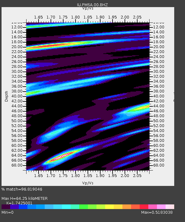
| Estimated Moho Depth: |
64.25 km |
| Estimated Crust Vp/Vs: |
1.74 |
| Assumed Crust Vp: |
6.183 km/s |
| Estimated Crust Vs: |
3.548 km/s |
| Estimated Crust Poisson's Ratio: |
0.25 |
|
| Radial Match: |
96.819046 % |
| Radial Bump: |
383 |
| Transverse Match: |
86.98611 % |
| Transverse Bump: |
400 |
| SOD ConfigId: |
2475 |
| Insert Time: |
2010-03-04 15:27:28.854 +0000 |
| GWidth: |
2.5 |
| Max Bumps: |
400 |
| Tol: |
0.001 |
|

Signal To Noise
| Channel | StoN | STA | LTA |
| IU:PMSA:00:BHN:20050926T02:04:59.011003Z | 15.511245 | 1.4409503E-5 | 9.289714E-7 |
| IU:PMSA:00:BHE:20050926T02:04:59.011003Z | 8.452746 | 2.9679486E-6 | 3.5112242E-7 |
| IU:PMSA:00:BHZ:20050926T02:04:59.011003Z | 37.08064 | 2.8127955E-5 | 7.585617E-7 |
| Arrivals |
| Ps | 8.1 SECOND |
| PpPs | 27 SECOND |
| PsPs/PpSs | 35 SECOND |


