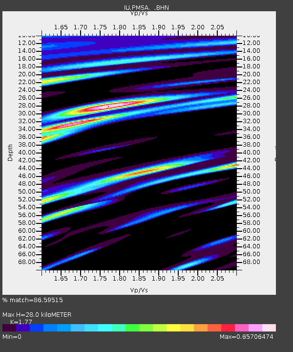
PMSA Palmer Station, Antarctica - Earthquake Result Viewer
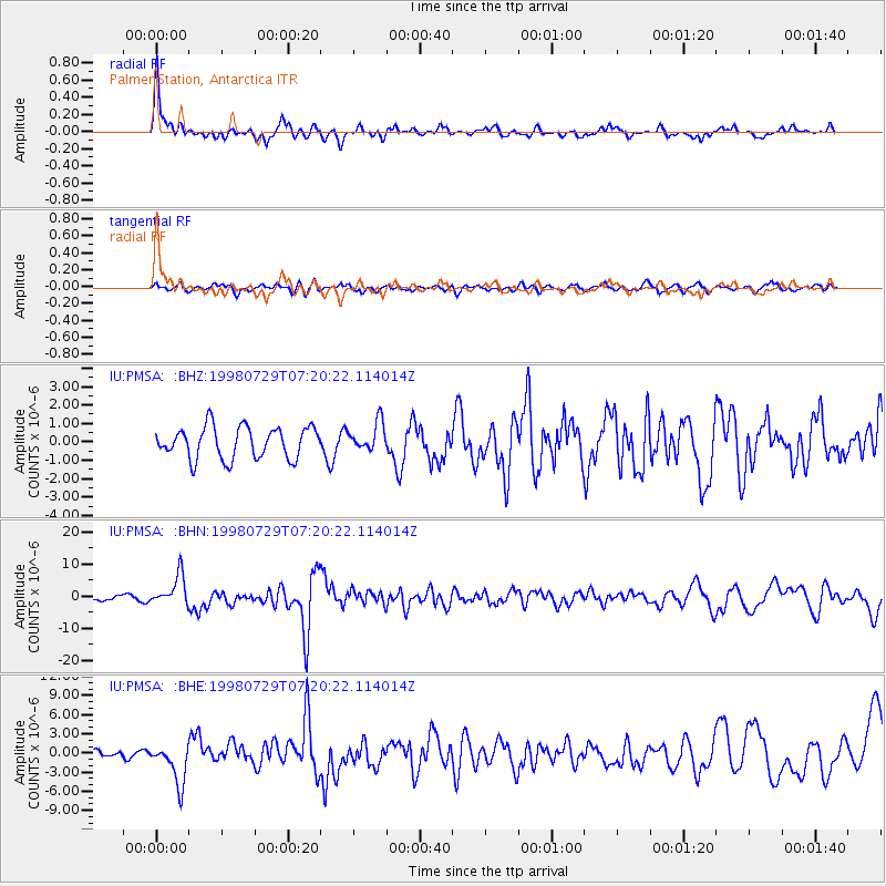
Earthquake location: Near Coast Of Central Chile
Earthquake latitude/longitude: -32.3/-71.3
Earthquake time(UTC): 1998/07/29 (210) 07:14:24 GMT
Earthquake Depth: 51 km
Earthquake Magnitude: 6.3 MB, 6.5 UNKNOWN, 6.5 ME
Earthquake Catalog/Contributor: WHDF/NEIC
Network: IU Global Seismograph Network (GSN - IRIS/USGS)
Station: PMSA Palmer Station, Antarctica
Lat/Lon: 64.77 S/64.05 W
Elevation: 40 m
Distance: 32.8 deg
Az: 174.28 deg
Baz: 348.641 deg
Ray Param: 0.0783916
Estimated Moho Depth: 28.0 km
Estimated Crust Vp/Vs: 1.77
Assumed Crust Vp: 6.183 km/s
Estimated Crust Vs: 3.493 km/s
Estimated Crust Poisson's Ratio: 0.27
Radial Match: 86.59515 %
Radial Bump: 400
Transverse Match: 58.480125 %
Transverse Bump: 400
SOD ConfigId: 4480
Insert Time: 2010-03-04 15:27:34.269 +0000
GWidth: 2.5
Max Bumps: 400
Tol: 0.001

Signal To Noise

ChannelStoNSTALTA
IU:PMSA: :BHN:19980729T07:20:22.114014Z7.15779354.677368E-66.534651E-7
IU:PMSA: :BHE:19980729T07:20:22.114014Z5.2078773.1462766E-66.0413805E-7
IU:PMSA: :BHZ:19980729T07:20:22.114014Z0.91847787.8543786E-78.551517E-7
Arrivals
Ps3.7 SECOND
PpPs12 SECOND
PsPs/PpSs15 SECOND