You are here: Home > Network List > TA - USArray Transportable Network (new EarthScope stations) Stations List
> Station L04D Klamath Falls, OR, USA > Earthquake Result Viewer
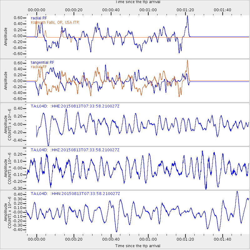
L04D Klamath Falls, OR, USA - Earthquake Result Viewer
*The percent match for this event was below the threshold and hence no stack was calculated.
| Earthquake location: |
Kuril Islands |
| Earthquake latitude/longitude: |
46.3/152.0 |
| Earthquake time(UTC): |
2015/08/13 (225) 07:24:40 GMT |
| Earthquake Depth: |
80 km |
| Earthquake Magnitude: |
4.6 mb |
| Earthquake Catalog/Contributor: |
ISC/ISC |
|
| Network: |
TA USArray Transportable Network (new EarthScope stations) |
| Station: |
L04D Klamath Falls, OR, USA |
| Lat/Lon: |
42.22 N/122.30 W |
| Elevation: |
1437 m |
|
| Distance: |
58.6 deg |
| Az: |
60.217 deg |
| Baz: |
305.885 deg |
| Ray Param: |
$rayparam |
*The percent match for this event was below the threshold and hence was not used in the summary stack. |
|
| Radial Match: |
44.356724 % |
| Radial Bump: |
400 |
| Transverse Match: |
40.70908 % |
| Transverse Bump: |
400 |
| SOD ConfigId: |
7422571 |
| Insert Time: |
2019-04-20 08:47:52.631 +0000 |
| GWidth: |
2.5 |
| Max Bumps: |
400 |
| Tol: |
0.001 |
|
Signal To Noise
| Channel | StoN | STA | LTA |
| TA:L04D: :HHZ:20150813T07:33:58.210027Z | 0.83715326 | 9.5581186E-8 | 1.1417405E-7 |
| TA:L04D: :HHN:20150813T07:33:58.210027Z | 0.80118215 | 1.0419017E-7 | 1.3004555E-7 |
| TA:L04D: :HHE:20150813T07:33:58.210027Z | 0.71952516 | 1.4509904E-7 | 2.0165943E-7 |
| Arrivals |
| Ps | |
| PpPs | |
| PsPs/PpSs | |


