You are here: Home > Network List > IU - Global Seismograph Network (GSN - IRIS/USGS) Stations List
> Station PMSA Palmer Station, Antarctica > Earthquake Result Viewer
PMSA Palmer Station, Antarctica - Earthquake Result Viewer
| Earthquake location: |
Santa Cruz Islands |
| Earthquake latitude/longitude: |
-12.9/166.7 |
| Earthquake time(UTC): |
1999/02/06 (037) 21:47:59 GMT |
| Earthquake Depth: |
90 km |
| Earthquake Magnitude: |
6.3 MB, 7.3 MS, 7.4 MW, 7.0 ME |
| Earthquake Catalog/Contributor: |
WHDF/NEIC |
|
| Network: |
IU Global Seismograph Network (GSN - IRIS/USGS) |
| Station: |
PMSA Palmer Station, Antarctica |
| Lat/Lon: |
64.77 S/64.05 W |
| Elevation: |
40 m |
|
| Distance: |
93.7 deg |
| Az: |
160.578 deg |
| Baz: |
229.181 deg |
| Ray Param: |
0.041156672 |
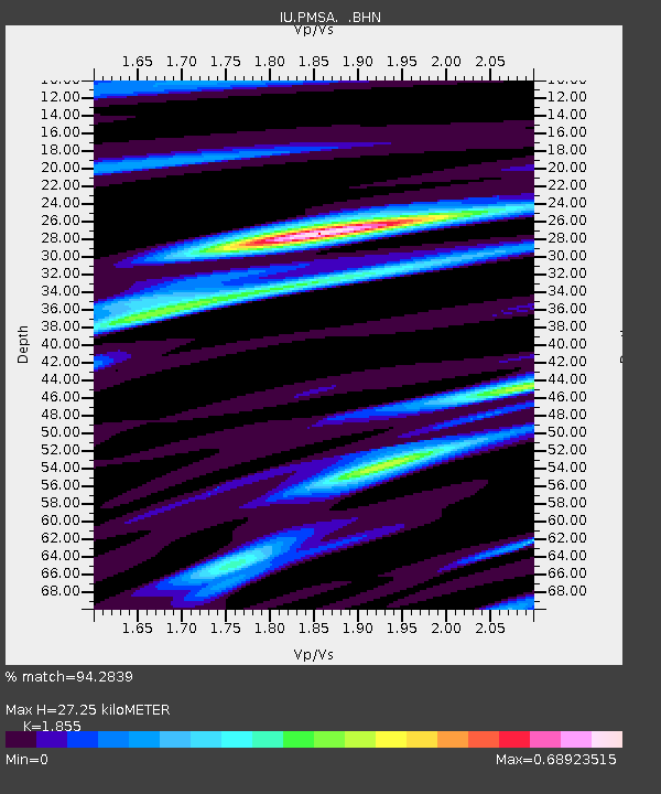
| Estimated Moho Depth: |
27.25 km |
| Estimated Crust Vp/Vs: |
1.86 |
| Assumed Crust Vp: |
6.183 km/s |
| Estimated Crust Vs: |
3.333 km/s |
| Estimated Crust Poisson's Ratio: |
0.30 |
|
| Radial Match: |
94.2839 % |
| Radial Bump: |
383 |
| Transverse Match: |
77.82617 % |
| Transverse Bump: |
400 |
| SOD ConfigId: |
4480 |
| Insert Time: |
2010-03-04 15:27:37.428 +0000 |
| GWidth: |
2.5 |
| Max Bumps: |
400 |
| Tol: |
0.001 |
|

Signal To Noise
| Channel | StoN | STA | LTA |
| IU:PMSA: :BHN:19990206T22:00:34.777007Z | 1.7802776 | 1.358079E-6 | 7.6284675E-7 |
| IU:PMSA: :BHE:19990206T22:00:34.777007Z | 1.9203075 | 1.594339E-6 | 8.302519E-7 |
| IU:PMSA: :BHZ:19990206T22:00:34.777007Z | 0.7729013 | 4.959819E-7 | 6.417144E-7 |
| Arrivals |
| Ps | 3.8 SECOND |
| PpPs | 12 SECOND |
| PsPs/PpSs | 16 SECOND |


