PMSA Palmer Station, Antarctica - Earthquake Result Viewer
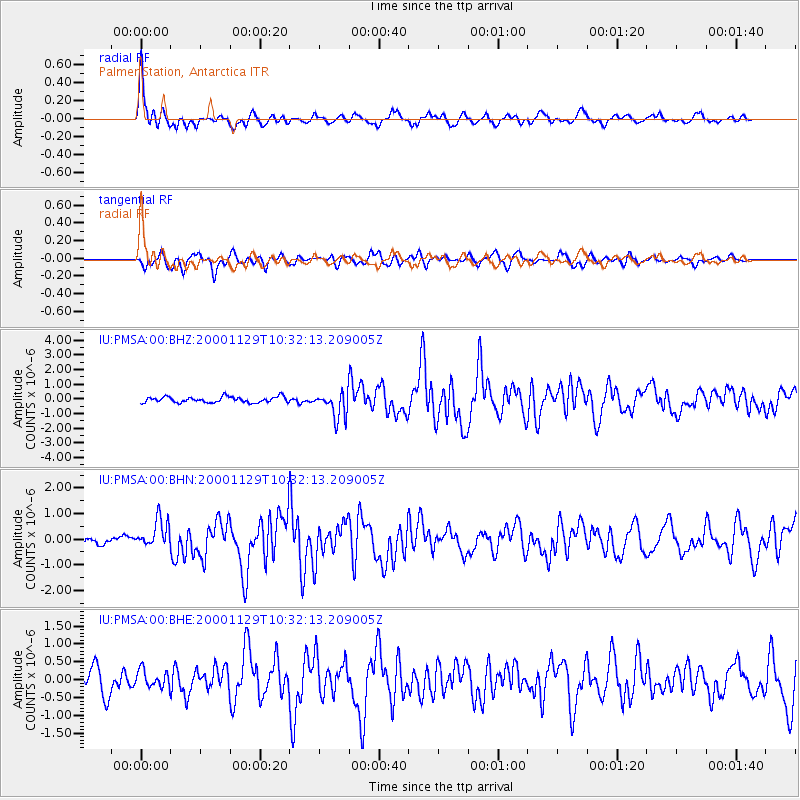
Earthquake location: Near Coast Of Northern Chile
Earthquake latitude/longitude: -24.9/-70.9
Earthquake time(UTC): 2000/11/29 (334) 10:25:13 GMT
Earthquake Depth: 58 km
Earthquake Magnitude: 5.8 MB, 5.9 MS, 6.4 MW, 6.3 MW
Earthquake Catalog/Contributor: WHDF/NEIC
Network: IU Global Seismograph Network (GSN - IRIS/USGS)
Station: PMSA Palmer Station, Antarctica
Lat/Lon: 64.77 S/64.05 W
Elevation: 40 m
Distance: 40.1 deg
Az: 175.462 deg
Baz: 350.345 deg
Ray Param: 0.07440868
Estimated Moho Depth: 35.75 km
Estimated Crust Vp/Vs: 1.60
Assumed Crust Vp: 6.183 km/s
Estimated Crust Vs: 3.858 km/s
Estimated Crust Poisson's Ratio: 0.18
Radial Match: 86.21838 %
Radial Bump: 400
Transverse Match: 73.57339 %
Transverse Bump: 400
SOD ConfigId: 3744
Insert Time: 2010-03-04 15:27:45.580 +0000
GWidth: 2.5
Max Bumps: 400
Tol: 0.001

Signal To Noise

ChannelStoNSTALTA
IU:PMSA:00:BHN:20001129T10:32:13.209005Z2.9825895.4908685E-71.840974E-7
IU:PMSA:00:BHE:20001129T10:32:13.209005Z0.74080072.4572807E-73.3170605E-7
IU:PMSA:00:BHZ:20001129T10:32:13.209005Z4.59106068.9619414E-71.9520415E-7
Arrivals
Ps3.7 SECOND
PpPs14 SECOND
PsPs/PpSs18 SECOND