You are here: Home > Network List > IU - Global Seismograph Network (GSN - IRIS/USGS) Stations List
> Station PMSA Palmer Station, Antarctica > Earthquake Result Viewer
PMSA Palmer Station, Antarctica - Earthquake Result Viewer
| Earthquake location: |
Michoacan, Mexico |
| Earthquake latitude/longitude: |
18.2/-102.5 |
| Earthquake time(UTC): |
2000/08/09 (222) 11:41:47 GMT |
| Earthquake Depth: |
46 km |
| Earthquake Magnitude: |
6.1 MB, 6.5 MS, 6.5 MW, 6.4 MW |
| Earthquake Catalog/Contributor: |
WHDF/NEIC |
|
| Network: |
IU Global Seismograph Network (GSN - IRIS/USGS) |
| Station: |
PMSA Palmer Station, Antarctica |
| Lat/Lon: |
64.77 S/64.05 W |
| Elevation: |
40 m |
|
| Distance: |
87.8 deg |
| Az: |
164.54 deg |
| Baz: |
323.75 deg |
| Ray Param: |
0.042997982 |
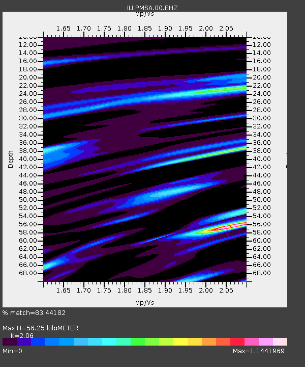
| Estimated Moho Depth: |
56.25 km |
| Estimated Crust Vp/Vs: |
2.06 |
| Assumed Crust Vp: |
6.183 km/s |
| Estimated Crust Vs: |
3.001 km/s |
| Estimated Crust Poisson's Ratio: |
0.35 |
|
| Radial Match: |
83.44182 % |
| Radial Bump: |
334 |
| Transverse Match: |
73.95365 % |
| Transverse Bump: |
400 |
| SOD ConfigId: |
3744 |
| Insert Time: |
2010-03-04 15:27:47.602 +0000 |
| GWidth: |
2.5 |
| Max Bumps: |
400 |
| Tol: |
0.001 |
|

Signal To Noise
| Channel | StoN | STA | LTA |
| IU:PMSA:00:BHN:20000809T11:54:00.884009Z | 3.8574674 | 7.06889E-7 | 1.832521E-7 |
| IU:PMSA:00:BHE:20000809T11:54:00.884009Z | 1.4454181 | 1.0316111E-6 | 7.137112E-7 |
| IU:PMSA:00:BHZ:20000809T11:54:00.884009Z | 4.0989075 | 1.9121321E-6 | 4.6649802E-7 |
| Arrivals |
| Ps | 9.8 SECOND |
| PpPs | 27 SECOND |
| PsPs/PpSs | 37 SECOND |


