You are here: Home > Network List > IU - Global Seismograph Network (GSN - IRIS/USGS) Stations List
> Station PMSA Palmer Station, Antarctica > Earthquake Result Viewer
PMSA Palmer Station, Antarctica - Earthquake Result Viewer
| Earthquake location: |
Vanuatu Islands Region |
| Earthquake latitude/longitude: |
-19.5/173.8 |
| Earthquake time(UTC): |
2000/02/25 (056) 01:43:58 GMT |
| Earthquake Depth: |
33 km |
| Earthquake Magnitude: |
6.1 MB, 7.1 MS, 7.1 MW, 7.0 MW |
| Earthquake Catalog/Contributor: |
WHDF/NEIC |
|
| Network: |
IU Global Seismograph Network (GSN - IRIS/USGS) |
| Station: |
PMSA Palmer Station, Antarctica |
| Lat/Lon: |
64.77 S/64.05 W |
| Elevation: |
40 m |
|
| Distance: |
85.1 deg |
| Az: |
158.641 deg |
| Baz: |
233.285 deg |
| Ray Param: |
0.04495656 |
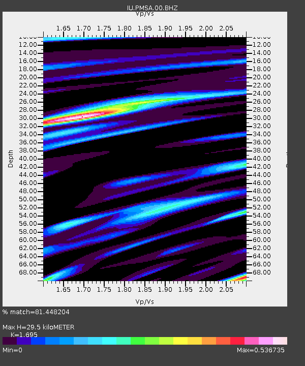
| Estimated Moho Depth: |
29.5 km |
| Estimated Crust Vp/Vs: |
1.70 |
| Assumed Crust Vp: |
6.183 km/s |
| Estimated Crust Vs: |
3.648 km/s |
| Estimated Crust Poisson's Ratio: |
0.23 |
|
| Radial Match: |
81.448204 % |
| Radial Bump: |
400 |
| Transverse Match: |
68.22139 % |
| Transverse Bump: |
400 |
| SOD ConfigId: |
3744 |
| Insert Time: |
2010-03-04 15:27:50.655 +0000 |
| GWidth: |
2.5 |
| Max Bumps: |
400 |
| Tol: |
0.001 |
|
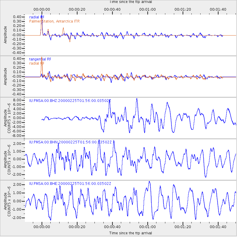
Signal To Noise
| Channel | StoN | STA | LTA |
| IU:PMSA:00:BHN:20000225T01:56:00.03502Z | 2.2198467 | 9.2715777E-7 | 4.1766748E-7 |
| IU:PMSA:00:BHE:20000225T01:56:00.03502Z | 3.0766604 | 9.99235E-7 | 3.2477908E-7 |
| IU:PMSA:00:BHZ:20000225T01:56:00.03502Z | 5.2801027 | 2.2926577E-6 | 4.3420704E-7 |
| Arrivals |
| Ps | 3.4 SECOND |
| PpPs | 13 SECOND |
| PsPs/PpSs | 16 SECOND |


