You are here: Home > Network List > IU - Global Seismograph Network (GSN - IRIS/USGS) Stations List
> Station PMSA Palmer Station, Antarctica > Earthquake Result Viewer
PMSA Palmer Station, Antarctica - Earthquake Result Viewer

| Earthquake location: |
Vanuatu Islands |
| Earthquake latitude/longitude: |
-15.1/167.4 |
| Earthquake time(UTC): |
1997/11/15 (319) 18:59:24 GMT |
| Earthquake Depth: |
123 km |
| Earthquake Magnitude: |
6.4 MB, 7.0 UNKNOWN, 6.8 ME |
| Earthquake Catalog/Contributor: |
WHDF/NEIC |
|
| Network: |
IU Global Seismograph Network (GSN - IRIS/USGS) |
| Station: |
PMSA Palmer Station, Antarctica |
| Lat/Lon: |
64.77 S/64.05 W |
| Elevation: |
40 m |
|
| Distance: |
91.3 deg |
| Az: |
160.421 deg |
| Baz: |
229.041 deg |
| Ray Param: |
0.041571014 |
| Estimated Moho Depth: |
28.5 km |
| Estimated Crust Vp/Vs: |
1.78 |
| Assumed Crust Vp: |
6.183 km/s |
| Estimated Crust Vs: |
3.469 km/s |
| Estimated Crust Poisson's Ratio: |
0.27 |
|
| Radial Match: |
86.71818 % |
| Radial Bump: |
391 |
| Transverse Match: |
76.16217 % |
| Transverse Bump: |
400 |
| SOD ConfigId: |
4480 |
| Insert Time: |
2010-03-04 15:28:07.627 +0000 |
| GWidth: |
2.5 |
| Max Bumps: |
400 |
| Tol: |
0.001 |
|
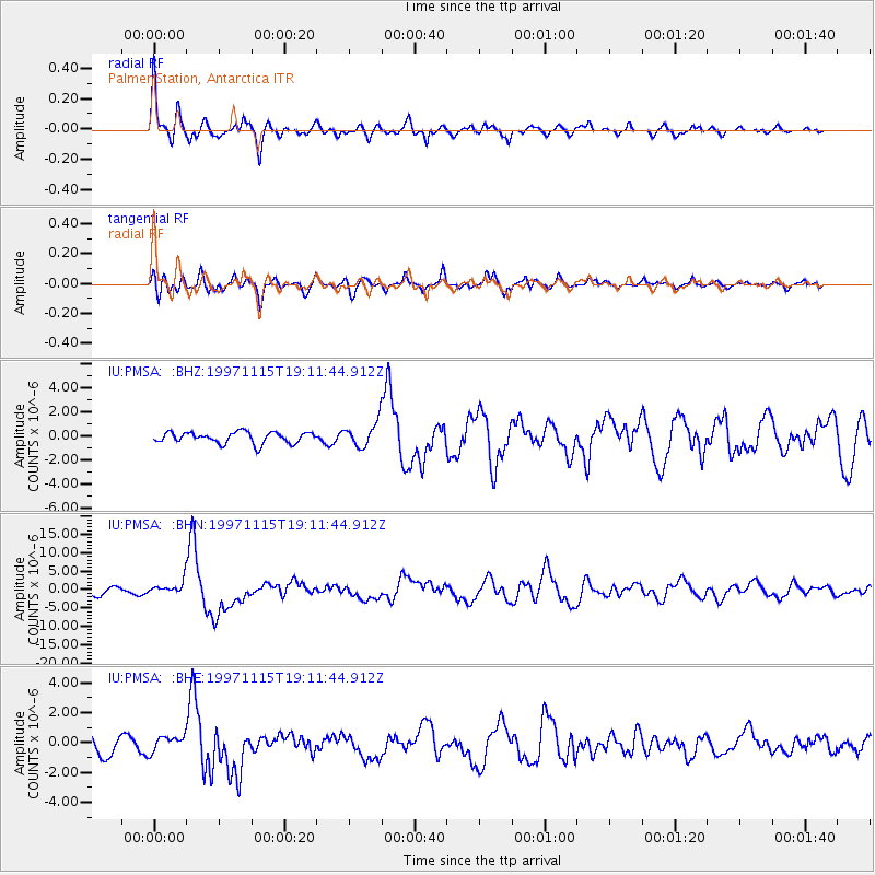
Signal To Noise
| Channel | StoN | STA | LTA |
| IU:PMSA: :BHN:19971115T19:11:44.912Z | 2.5243628 | 1.7839466E-6 | 7.066918E-7 |
| IU:PMSA: :BHE:19971115T19:11:44.912Z | 0.97511905 | 5.4352745E-7 | 5.57396E-7 |
| IU:PMSA: :BHZ:19971115T19:11:44.912Z | 2.1694865 | 1.0128599E-6 | 4.668662E-7 |
| Arrivals |
| Ps | 3.7 SECOND |
| PpPs | 13 SECOND |
| PsPs/PpSs | 16 SECOND |


