You are here: Home > Network List > IU - Global Seismograph Network (GSN - IRIS/USGS) Stations List
> Station CTAO Charters Towers, Australia > Earthquake Result Viewer
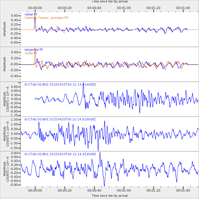
CTAO Charters Towers, Australia - Earthquake Result Viewer
*The percent match for this event was below the threshold and hence no stack was calculated.
| Earthquake location: |
Southern Sumatra, Indonesia |
| Earthquake latitude/longitude: |
-5.7/102.5 |
| Earthquake time(UTC): |
2015/04/20 (110) 09:05:31 GMT |
| Earthquake Depth: |
10 km |
| Earthquake Magnitude: |
6.0 MWP |
| Earthquake Catalog/Contributor: |
NEIC PDE/NEIC COMCAT |
|
| Network: |
IU Global Seismograph Network (GSN - IRIS/USGS) |
| Station: |
CTAO Charters Towers, Australia |
| Lat/Lon: |
20.09 S/146.25 E |
| Elevation: |
357 m |
|
| Distance: |
44.8 deg |
| Az: |
112.733 deg |
| Baz: |
282.461 deg |
| Ray Param: |
$rayparam |
*The percent match for this event was below the threshold and hence was not used in the summary stack. |
|
| Radial Match: |
69.491135 % |
| Radial Bump: |
358 |
| Transverse Match: |
60.90003 % |
| Transverse Bump: |
400 |
| SOD ConfigId: |
872571 |
| Insert Time: |
2015-05-04 09:25:13.263 +0000 |
| GWidth: |
2.5 |
| Max Bumps: |
400 |
| Tol: |
0.001 |
|
Signal To Noise
| Channel | StoN | STA | LTA |
| IU:CTAO:00:BHZ:20150420T09:13:14.919008Z | 1.5814669 | 4.191458E-7 | 2.6503608E-7 |
| IU:CTAO:00:BH1:20150420T09:13:14.919008Z | 1.2565507 | 2.840886E-7 | 2.2608606E-7 |
| IU:CTAO:00:BH2:20150420T09:13:14.919008Z | 3.1200426 | 4.6794491E-7 | 1.499803E-7 |
| Arrivals |
| Ps | |
| PpPs | |
| PsPs/PpSs | |


