You are here: Home > Network List > IU - Global Seismograph Network (GSN - IRIS/USGS) Stations List
> Station PMSA Palmer Station, Antarctica > Earthquake Result Viewer
PMSA Palmer Station, Antarctica - Earthquake Result Viewer
*The percent match for this event was below the threshold and hence no stack was calculated.
| Earthquake location: |
Gulf Of California |
| Earthquake latitude/longitude: |
26.2/-110.3 |
| Earthquake time(UTC): |
1995/08/28 (240) 10:46:12 GMT |
| Earthquake Depth: |
10 km |
| Earthquake Magnitude: |
5.6 MB, 6.5 MS |
| Earthquake Catalog/Contributor: |
WHDF/NEIC |
|
| Network: |
IU Global Seismograph Network (GSN - IRIS/USGS) |
| Station: |
PMSA Palmer Station, Antarctica |
| Lat/Lon: |
64.77 S/64.05 W |
| Elevation: |
40 m |
|
| Distance: |
97.5 deg |
| Az: |
161.792 deg |
| Baz: |
319.055 deg |
| Ray Param: |
$rayparam |
*The percent match for this event was below the threshold and hence was not used in the summary stack. |
|
| Radial Match: |
72.5873 % |
| Radial Bump: |
400 |
| Transverse Match: |
73.65963 % |
| Transverse Bump: |
400 |
| SOD ConfigId: |
4480 |
| Insert Time: |
2010-03-04 15:31:22.232 +0000 |
| GWidth: |
2.5 |
| Max Bumps: |
400 |
| Tol: |
0.001 |
|
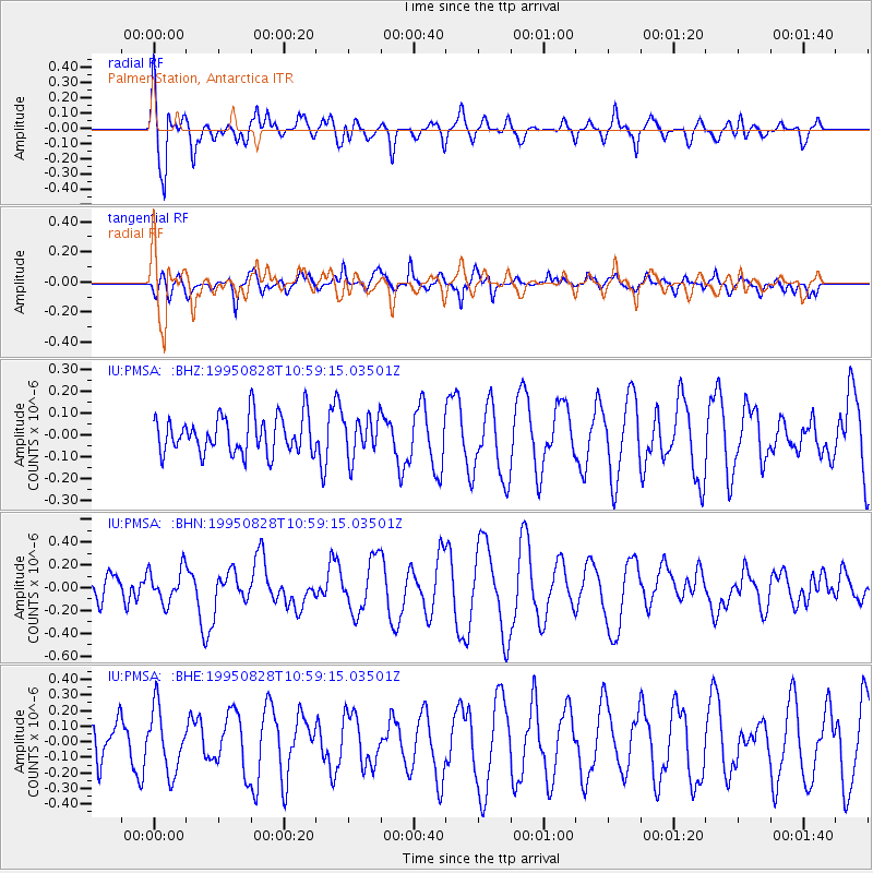
Signal To Noise
| Channel | StoN | STA | LTA |
| IU:PMSA: :BHN:19950828T10:59:15.03501Z | 0.7096267 | 1.4848999E-7 | 2.0925086E-7 |
| IU:PMSA: :BHE:19950828T10:59:15.03501Z | 2.2170014 | 2.0155653E-7 | 9.091403E-8 |
| IU:PMSA: :BHZ:19950828T10:59:15.03501Z | 1.0643841 | 8.999053E-8 | 8.454705E-8 |
| Arrivals |
| Ps | |
| PpPs | |
| PsPs/PpSs | |


