You are here: Home > Network List > CI - Caltech Regional Seismic Network Stations List
> Station GLA Glamis, Glamis, CA, USA > Earthquake Result Viewer
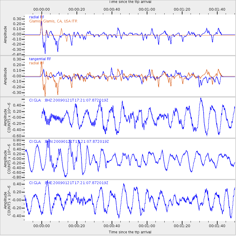
GLA Glamis, Glamis, CA, USA - Earthquake Result Viewer
*The percent match for this event was below the threshold and hence no stack was calculated.
| Earthquake location: |
Southeast Of Loyalty Islands |
| Earthquake latitude/longitude: |
-22.7/171.0 |
| Earthquake time(UTC): |
2009/01/21 (021) 17:08:42 GMT |
| Earthquake Depth: |
24 km |
| Earthquake Magnitude: |
5.8 MS, 5.4 MB, 6.1 MW, 6.1 MW |
| Earthquake Catalog/Contributor: |
WHDF/NEIC |
|
| Network: |
CI Caltech Regional Seismic Network |
| Station: |
GLA Glamis, Glamis, CA, USA |
| Lat/Lon: |
33.05 N/114.83 W |
| Elevation: |
610 m |
|
| Distance: |
89.8 deg |
| Az: |
53.886 deg |
| Baz: |
242.665 deg |
| Ray Param: |
$rayparam |
*The percent match for this event was below the threshold and hence was not used in the summary stack. |
|
| Radial Match: |
76.716736 % |
| Radial Bump: |
343 |
| Transverse Match: |
59.006657 % |
| Transverse Bump: |
400 |
| SOD ConfigId: |
2834 |
| Insert Time: |
2010-02-25 23:36:11.792 +0000 |
| GWidth: |
2.5 |
| Max Bumps: |
400 |
| Tol: |
0.001 |
|
Signal To Noise
| Channel | StoN | STA | LTA |
| CI:GLA: :BHN:20090121T17:21:07.872019Z | 1.9731439 | 4.4332475E-7 | 2.2467938E-7 |
| CI:GLA: :BHE:20090121T17:21:07.872019Z | 1.4232785 | 2.7939842E-7 | 1.9630623E-7 |
| CI:GLA: :BHZ:20090121T17:21:07.872019Z | 1.6034956 | 2.7064164E-7 | 1.6878228E-7 |
| Arrivals |
| Ps | |
| PpPs | |
| PsPs/PpSs | |


