You are here: Home > Network List > IU - Global Seismograph Network (GSN - IRIS/USGS) Stations List
> Station TSUM Tsumeb, Namibia > Earthquake Result Viewer
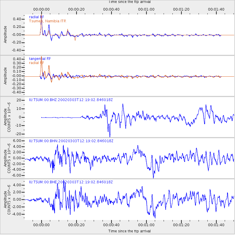
TSUM Tsumeb, Namibia - Earthquake Result Viewer

| Earthquake location: |
Hindu Kush Region, Afghanistan |
| Earthquake latitude/longitude: |
36.5/70.5 |
| Earthquake time(UTC): |
2002/03/03 (062) 12:08:19 GMT |
| Earthquake Depth: |
226 km |
| Earthquake Magnitude: |
6.6 MB, 7.4 MW, 7.3 MW |
| Earthquake Catalog/Contributor: |
WHDF/NEIC |
|
| Network: |
IU Global Seismograph Network (GSN - IRIS/USGS) |
| Station: |
TSUM Tsumeb, Namibia |
| Lat/Lon: |
19.20 S/17.58 E |
| Elevation: |
1240 m |
|
| Distance: |
74.6 deg |
| Az: |
231.429 deg |
| Baz: |
41.805 deg |
| Ray Param: |
0.05162829 |
| Estimated Moho Depth: |
10.0 km |
| Estimated Crust Vp/Vs: |
1.95 |
| Assumed Crust Vp: |
6.51 km/s |
| Estimated Crust Vs: |
3.339 km/s |
| Estimated Crust Poisson's Ratio: |
0.32 |
|
| Radial Match: |
97.17769 % |
| Radial Bump: |
373 |
| Transverse Match: |
89.05566 % |
| Transverse Bump: |
400 |
| SOD ConfigId: |
20082 |
| Insert Time: |
2010-03-04 15:31:39.597 +0000 |
| GWidth: |
2.5 |
| Max Bumps: |
400 |
| Tol: |
0.001 |
|
Signal To Noise
| Channel | StoN | STA | LTA |
| IU:TSUM:00:BHN:20020303T12:19:02.846018Z | 2.3899887 | 5.0905885E-7 | 2.1299635E-7 |
| IU:TSUM:00:BHE:20020303T12:19:02.846018Z | 4.3017235 | 4.5671274E-7 | 1.0616971E-7 |
| IU:TSUM:00:BHZ:20020303T12:19:02.846018Z | 5.0291977 | 1.4829544E-6 | 2.9486898E-7 |
| Arrivals |
| Ps | 1.5 SECOND |
| PpPs | 4.4 SECOND |
| PsPs/PpSs | 5.9 SECOND |


