You are here: Home > Network List > IU - Global Seismograph Network (GSN - IRIS/USGS) Stations List
> Station TSUM Tsumeb, Namibia > Earthquake Result Viewer
TSUM Tsumeb, Namibia - Earthquake Result Viewer
| Earthquake location: |
South Sandwich Islands Region |
| Earthquake latitude/longitude: |
-56.5/-27.5 |
| Earthquake time(UTC): |
2002/11/12 (316) 01:46:48 GMT |
| Earthquake Depth: |
120 km |
| Earthquake Magnitude: |
6.0 MB, 6.3 MW, 6.2 MW |
| Earthquake Catalog/Contributor: |
WHDF/NEIC |
|
| Network: |
IU Global Seismograph Network (GSN - IRIS/USGS) |
| Station: |
TSUM Tsumeb, Namibia |
| Lat/Lon: |
19.20 S/17.58 E |
| Elevation: |
1240 m |
|
| Distance: |
50.1 deg |
| Az: |
60.803 deg |
| Baz: |
210.766 deg |
| Ray Param: |
0.06787085 |
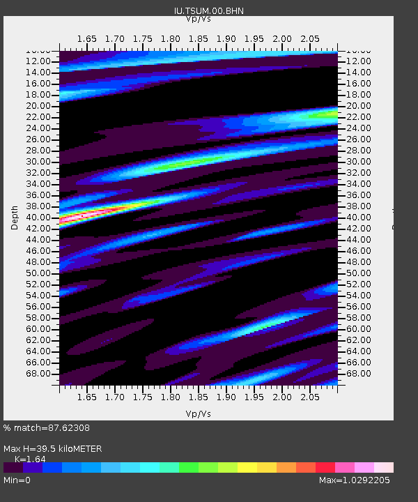
| Estimated Moho Depth: |
39.5 km |
| Estimated Crust Vp/Vs: |
1.64 |
| Assumed Crust Vp: |
6.51 km/s |
| Estimated Crust Vs: |
3.97 km/s |
| Estimated Crust Poisson's Ratio: |
0.20 |
|
| Radial Match: |
87.62308 % |
| Radial Bump: |
297 |
| Transverse Match: |
60.28364 % |
| Transverse Bump: |
400 |
| SOD ConfigId: |
4714 |
| Insert Time: |
2010-03-04 15:31:49.937 +0000 |
| GWidth: |
2.5 |
| Max Bumps: |
400 |
| Tol: |
0.001 |
|

Signal To Noise
| Channel | StoN | STA | LTA |
| IU:TSUM:00:BHN:20021112T01:55:01.196989Z | 4.6826925 | 5.4305366E-7 | 1.1597039E-7 |
| IU:TSUM:00:BHE:20021112T01:55:01.196989Z | 2.467104 | 3.7893275E-7 | 1.5359416E-7 |
| IU:TSUM:00:BHZ:20021112T01:55:01.196989Z | 7.057251 | 1.2541776E-6 | 1.7771477E-7 |
| Arrivals |
| Ps | 4.1 SECOND |
| PpPs | 15 SECOND |
| PsPs/PpSs | 19 SECOND |


