You are here: Home > Network List > IU - Global Seismograph Network (GSN - IRIS/USGS) Stations List
> Station TSUM Tsumeb, Namibia > Earthquake Result Viewer
TSUM Tsumeb, Namibia - Earthquake Result Viewer
| Earthquake location: |
Southern Sumatra, Indonesia |
| Earthquake latitude/longitude: |
-2.4/104.0 |
| Earthquake time(UTC): |
2004/07/25 (207) 14:35:19 GMT |
| Earthquake Depth: |
582 km |
| Earthquake Magnitude: |
6.8 MB, 7.3 MW, 7.3 MW |
| Earthquake Catalog/Contributor: |
WHDF/NEIC |
|
| Network: |
IU Global Seismograph Network (GSN - IRIS/USGS) |
| Station: |
TSUM Tsumeb, Namibia |
| Lat/Lon: |
19.20 S/17.58 E |
| Elevation: |
1240 m |
|
| Distance: |
85.8 deg |
| Az: |
251.033 deg |
| Baz: |
91.105 deg |
| Ray Param: |
0.042820614 |
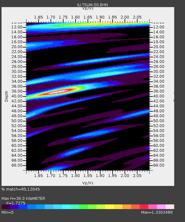
| Estimated Moho Depth: |
38.0 km |
| Estimated Crust Vp/Vs: |
1.73 |
| Assumed Crust Vp: |
6.51 km/s |
| Estimated Crust Vs: |
3.769 km/s |
| Estimated Crust Poisson's Ratio: |
0.25 |
|
| Radial Match: |
95.12845 % |
| Radial Bump: |
400 |
| Transverse Match: |
89.062515 % |
| Transverse Bump: |
400 |
| SOD ConfigId: |
2459 |
| Insert Time: |
2010-03-04 15:32:08.962 +0000 |
| GWidth: |
2.5 |
| Max Bumps: |
400 |
| Tol: |
0.001 |
|

Signal To Noise
| Channel | StoN | STA | LTA |
| IU:TSUM:00:BHN:20040725T14:46:26.411013Z | 0.95107865 | 1.527426E-7 | 1.6059934E-7 |
| IU:TSUM:00:BHE:20040725T14:46:26.411013Z | 9.466566 | 1.5623543E-6 | 1.6503918E-7 |
| IU:TSUM:00:BHZ:20040725T14:46:26.411013Z | 24.82591 | 5.5127452E-6 | 2.2205612E-7 |
| Arrivals |
| Ps | 4.3 SECOND |
| PpPs | 16 SECOND |
| PsPs/PpSs | 20 SECOND |


