You are here: Home > Network List > IU - Global Seismograph Network (GSN - IRIS/USGS) Stations List
> Station TSUM Tsumeb, Namibia > Earthquake Result Viewer
TSUM Tsumeb, Namibia - Earthquake Result Viewer
| Earthquake location: |
South Sandwich Islands Region |
| Earthquake latitude/longitude: |
-58.0/-25.3 |
| Earthquake time(UTC): |
2004/09/11 (255) 21:52:38 GMT |
| Earthquake Depth: |
64 km |
| Earthquake Magnitude: |
5.8 MB, 6.1 MW, 6.1 MW |
| Earthquake Catalog/Contributor: |
WHDF/NEIC |
|
| Network: |
IU Global Seismograph Network (GSN - IRIS/USGS) |
| Station: |
TSUM Tsumeb, Namibia |
| Lat/Lon: |
19.20 S/17.58 E |
| Elevation: |
1240 m |
|
| Distance: |
49.8 deg |
| Az: |
57.415 deg |
| Baz: |
208.364 deg |
| Ray Param: |
0.068288274 |
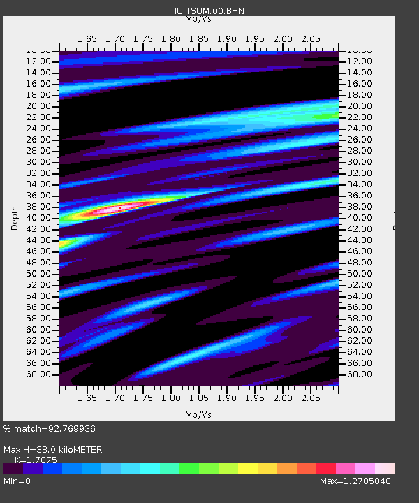
| Estimated Moho Depth: |
38.0 km |
| Estimated Crust Vp/Vs: |
1.71 |
| Assumed Crust Vp: |
6.51 km/s |
| Estimated Crust Vs: |
3.813 km/s |
| Estimated Crust Poisson's Ratio: |
0.24 |
|
| Radial Match: |
92.769936 % |
| Radial Bump: |
321 |
| Transverse Match: |
66.82473 % |
| Transverse Bump: |
400 |
| SOD ConfigId: |
2459 |
| Insert Time: |
2010-03-04 15:32:13.072 +0000 |
| GWidth: |
2.5 |
| Max Bumps: |
400 |
| Tol: |
0.001 |
|
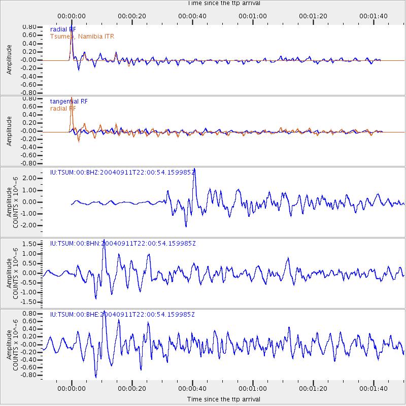
Signal To Noise
| Channel | StoN | STA | LTA |
| IU:TSUM:00:BHN:20040911T22:00:54.159985Z | 3.6143634 | 2.3859562E-7 | 6.601318E-8 |
| IU:TSUM:00:BHE:20040911T22:00:54.159985Z | 1.9642837 | 2.0087568E-7 | 1.0226408E-7 |
| IU:TSUM:00:BHZ:20040911T22:00:54.159985Z | 5.9502044 | 5.4032074E-7 | 9.0807085E-8 |
| Arrivals |
| Ps | 4.4 SECOND |
| PpPs | 15 SECOND |
| PsPs/PpSs | 19 SECOND |


