You are here: Home > Network List > AV - Alaska Volcano Observatory Stations List
> Station SPCR Ckakachatna River, Mount Spurr, Alaska > Earthquake Result Viewer
SPCR Ckakachatna River, Mount Spurr, Alaska - Earthquake Result Viewer
*The percent match for this event was below the threshold and hence no stack was calculated.
| Earthquake location: |
South Of Kermadec Islands |
| Earthquake latitude/longitude: |
-32.9/-178.2 |
| Earthquake time(UTC): |
2015/08/13 (225) 15:58:31 GMT |
| Earthquake Depth: |
10 km |
| Earthquake Magnitude: |
5.3 MW |
| Earthquake Catalog/Contributor: |
ISC/ISC |
|
| Network: |
AV Alaska Volcano Observatory |
| Station: |
SPCR Ckakachatna River, Mount Spurr, Alaska |
| Lat/Lon: |
61.20 N/152.21 W |
| Elevation: |
984 m |
|
| Distance: |
96.1 deg |
| Az: |
12.32 deg |
| Baz: |
201.761 deg |
| Ray Param: |
$rayparam |
*The percent match for this event was below the threshold and hence was not used in the summary stack. |
|
| Radial Match: |
52.989918 % |
| Radial Bump: |
370 |
| Transverse Match: |
55.51056 % |
| Transverse Bump: |
400 |
| SOD ConfigId: |
7422571 |
| Insert Time: |
2019-04-20 09:25:15.529 +0000 |
| GWidth: |
2.5 |
| Max Bumps: |
400 |
| Tol: |
0.001 |
|
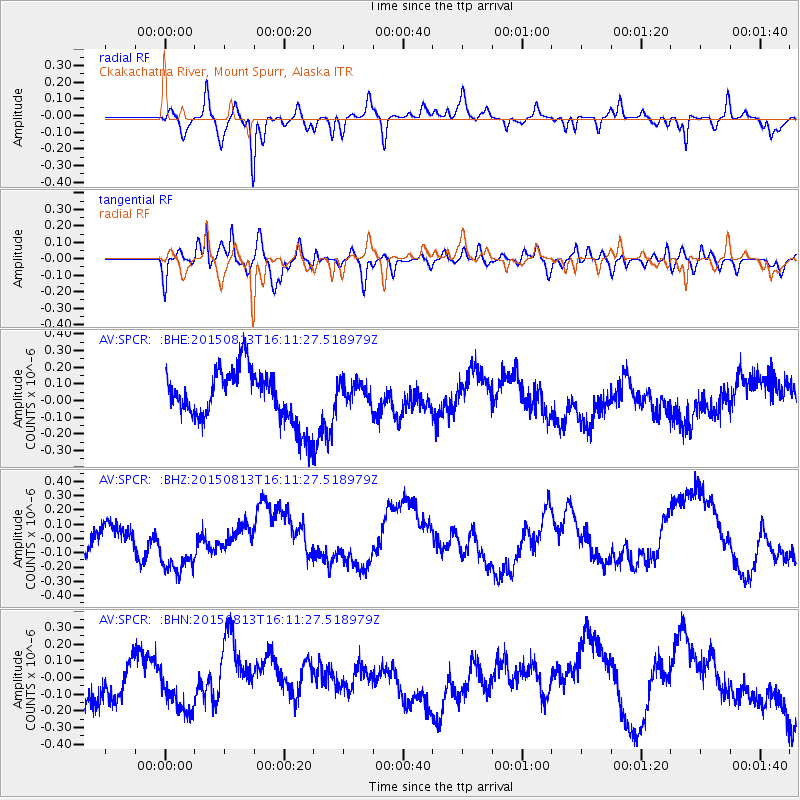
Signal To Noise
| Channel | StoN | STA | LTA |
| AV:SPCR: :BHZ:20150813T16:11:27.518979Z | 2.0938344 | 2.2964927E-7 | 1.0967881E-7 |
| AV:SPCR: :BHN:20150813T16:11:27.518979Z | 1.2195152 | 1.6372135E-7 | 1.3425118E-7 |
| AV:SPCR: :BHE:20150813T16:11:27.518979Z | 0.4733111 | 7.476975E-8 | 1.5797168E-7 |
| Arrivals |
| Ps | |
| PpPs | |
| PsPs/PpSs | |


