You are here: Home > Network List > IU - Global Seismograph Network (GSN - IRIS/USGS) Stations List
> Station TSUM Tsumeb, Namibia > Earthquake Result Viewer
TSUM Tsumeb, Namibia - Earthquake Result Viewer
| Earthquake location: |
Southern Bolivia |
| Earthquake latitude/longitude: |
-20.1/-65.0 |
| Earthquake time(UTC): |
2008/10/12 (286) 20:55:41 GMT |
| Earthquake Depth: |
353 km |
| Earthquake Magnitude: |
6.0 MB, 6.2 MW, 6.2 MW |
| Earthquake Catalog/Contributor: |
WHDF/NEIC |
|
| Network: |
IU Global Seismograph Network (GSN - IRIS/USGS) |
| Station: |
TSUM Tsumeb, Namibia |
| Lat/Lon: |
19.20 S/17.58 E |
| Elevation: |
1260 m |
|
| Distance: |
76.9 deg |
| Az: |
105.81 deg |
| Baz: |
253.083 deg |
| Ray Param: |
0.049700297 |
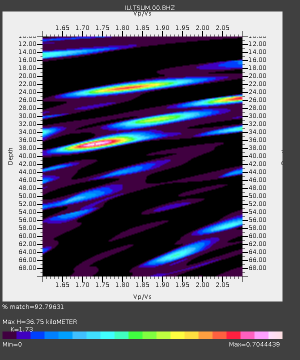
| Estimated Moho Depth: |
36.75 km |
| Estimated Crust Vp/Vs: |
1.73 |
| Assumed Crust Vp: |
6.51 km/s |
| Estimated Crust Vs: |
3.763 km/s |
| Estimated Crust Poisson's Ratio: |
0.25 |
|
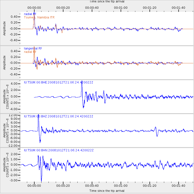
| Radial Match: |
92.79631 % |
| Radial Bump: |
398 |
| Transverse Match: |
85.639465 % |
| Transverse Bump: |
400 |
| SOD ConfigId: |
2556 |
| Insert Time: |
2010-03-04 15:32:31.079 +0000 |
| GWidth: |
2.5 |
| Max Bumps: |
400 |
| Tol: |
0.001 |
|
Signal To Noise
| Channel | StoN | STA | LTA |
| IU:TSUM:00:BHZ:20081012T21:06:24.420022Z | 32.24621 | 4.7943386E-6 | 1.4867915E-7 |
| IU:TSUM:00:BHN:20081012T21:06:24.420022Z | 7.7922287 | 7.359871E-7 | 9.445142E-8 |
| IU:TSUM:00:BHE:20081012T21:06:24.420022Z | 13.507341 | 1.9133772E-6 | 1.4165461E-7 |
| Arrivals |
| Ps | 4.3 SECOND |
| PpPs | 15 SECOND |
| PsPs/PpSs | 19 SECOND |


