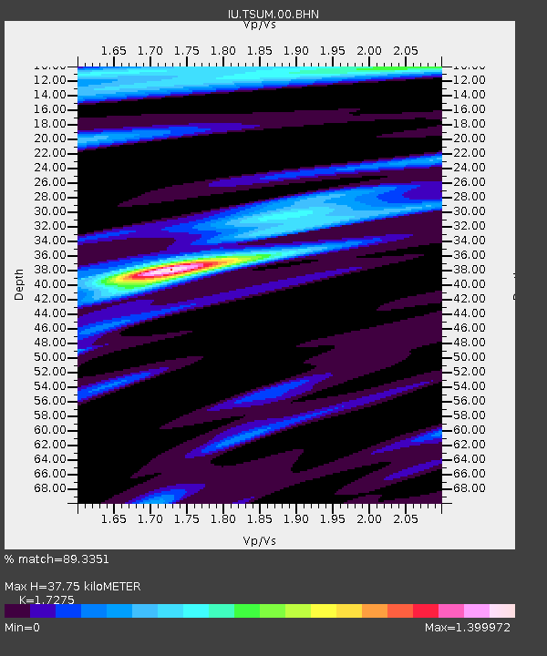
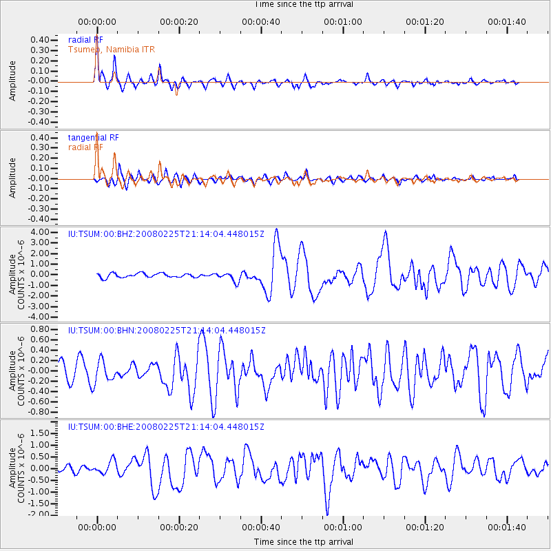
TSUM Tsumeb, Namibia - Earthquake Result Viewer

Earthquake location: Southern Sumatra, Indonesia
Earthquake latitude/longitude: -2.2/99.8
Earthquake time(UTC): 2008/02/25 (056) 21:02:18 GMT
Earthquake Depth: 25 km
Earthquake Magnitude: 6.2 MB, 6.6 MS, 6.6 MW, 6.5 MW
Earthquake Catalog/Contributor: WHDF/NEIC
Network: IU Global Seismograph Network (GSN - IRIS/USGS)
Station: TSUM Tsumeb, Namibia
Lat/Lon: 19.20 S/17.58 E
Elevation: 1240 m
Distance: 81.9 deg
Az: 251.038 deg
Baz: 89.57 deg
Ray Param: 0.04721674
Estimated Moho Depth: 37.75 km
Estimated Crust Vp/Vs: 1.73
Assumed Crust Vp: 6.51 km/s
Estimated Crust Vs: 3.769 km/s
Estimated Crust Poisson's Ratio: 0.25
Radial Match: 89.3351 %
Radial Bump: 400
Transverse Match: 77.5224 %
Transverse Bump: 400
SOD ConfigId: 2564
Insert Time: 2010-03-04 15:32:41.719 +0000
GWidth: 2.5
Max Bumps: 400
Tol: 0.001

Signal To Noise

ChannelStoNSTALTA
IU:TSUM:00:BHN:20080225T21:14:04.448015Z1.21044211.995178E-71.6483052E-7
IU:TSUM:00:BHE:20080225T21:14:04.448015Z1.54685032.7454945E-71.7748934E-7
IU:TSUM:00:BHZ:20080225T21:14:04.448015Z2.2671754.4923598E-71.9814793E-7
Arrivals
Ps4.3 SECOND
PpPs15 SECOND
PsPs/PpSs20 SECOND