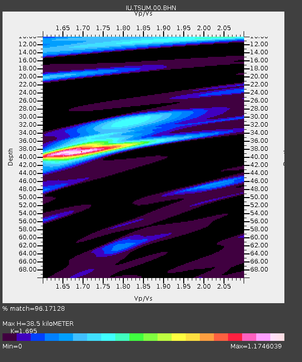
TSUM Tsumeb, Namibia - Earthquake Result Viewer

Earthquake location: Southern Sumatra, Indonesia
Earthquake latitude/longitude: -2.5/100.0
Earthquake time(UTC): 2008/02/25 (056) 08:36:33 GMT
Earthquake Depth: 25 km
Earthquake Magnitude: 6.4 MB, 7.3 MS, 7.0 MW, 6.9 MW
Earthquake Catalog/Contributor: WHDF/NEIC
Network: IU Global Seismograph Network (GSN - IRIS/USGS)
Station: TSUM Tsumeb, Namibia
Lat/Lon: 19.20 S/17.58 E
Elevation: 1240 m
Distance: 82.0 deg
Az: 251.071 deg
Baz: 89.853 deg
Ray Param: 0.04716248
Estimated Moho Depth: 38.5 km
Estimated Crust Vp/Vs: 1.70
Assumed Crust Vp: 6.51 km/s
Estimated Crust Vs: 3.841 km/s
Estimated Crust Poisson's Ratio: 0.23
Radial Match: 96.17128 %
Radial Bump: 332
Transverse Match: 78.148674 %
Transverse Bump: 400
SOD ConfigId: 2564
Insert Time: 2010-03-04 15:32:44.556 +0000
GWidth: 2.5
Max Bumps: 400
Tol: 0.001

Signal To Noise

ChannelStoNSTALTA
IU:TSUM:00:BHN:20080225T08:48:19.498018Z0.500900751.09325455E-72.1825772E-7
IU:TSUM:00:BHE:20080225T08:48:19.498018Z2.53682523.2156183E-71.2675757E-7
IU:TSUM:00:BHZ:20080225T08:48:19.498018Z1.60648422.9400496E-71.8301141E-7
Arrivals
Ps4.2 SECOND
PpPs15 SECOND
PsPs/PpSs20 SECOND