You are here: Home > Network List > YN10 - San Jacinto Fault Zone Stations List
> Station GVAR1 GVAR1, Anza, CA, USA > Earthquake Result Viewer
GVAR1 GVAR1, Anza, CA, USA - Earthquake Result Viewer
| Earthquake location: |
South Of Kermadec Islands |
| Earthquake latitude/longitude: |
-32.9/-178.2 |
| Earthquake time(UTC): |
2015/08/13 (225) 15:58:31 GMT |
| Earthquake Depth: |
10 km |
| Earthquake Magnitude: |
5.3 MW |
| Earthquake Catalog/Contributor: |
ISC/ISC |
|
| Network: |
YN San Jacinto Fault Zone |
| Station: |
GVAR1 GVAR1, Anza, CA, USA |
| Lat/Lon: |
33.67 N/116.71 W |
| Elevation: |
1328 m |
|
| Distance: |
87.9 deg |
| Az: |
47.166 deg |
| Baz: |
227.714 deg |
| Ray Param: |
0.042990007 |
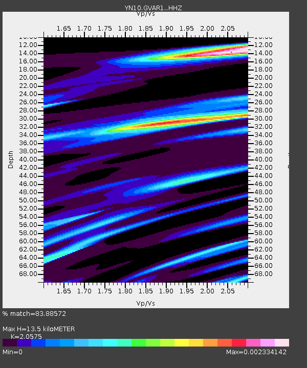
| Estimated Moho Depth: |
13.5 km |
| Estimated Crust Vp/Vs: |
2.06 |
| Assumed Crust Vp: |
6.264 km/s |
| Estimated Crust Vs: |
3.044 km/s |
| Estimated Crust Poisson's Ratio: |
0.35 |
|
| Radial Match: |
83.88572 % |
| Radial Bump: |
400 |
| Transverse Match: |
72.23974 % |
| Transverse Bump: |
400 |
| SOD ConfigId: |
7422571 |
| Insert Time: |
2019-04-20 09:28:44.488 +0000 |
| GWidth: |
2.5 |
| Max Bumps: |
400 |
| Tol: |
0.001 |
|

Signal To Noise
| Channel | StoN | STA | LTA |
| YN:GVAR1: :HHZ:20150813T16:10:49.583982Z | 0.356223 | 1.4159323E-4 | 3.9748484E-4 |
| YN:GVAR1: :HHN:20150813T16:10:49.583982Z | 0.9765617 | 6.460005E-7 | 6.6150506E-7 |
| YN:GVAR1: :HHE:20150813T16:10:49.583982Z | 0.46318984 | 3.3371325E-7 | 7.2046754E-7 |
| Arrivals |
| Ps | 2.3 SECOND |
| PpPs | 6.5 SECOND |
| PsPs/PpSs | 8.8 SECOND |


