You are here: Home > Network List > IU - Global Seismograph Network (GSN - IRIS/USGS) Stations List
> Station TSUM Tsumeb, Namibia > Earthquake Result Viewer
TSUM Tsumeb, Namibia - Earthquake Result Viewer
| Earthquake location: |
Cyprus Region |
| Earthquake latitude/longitude: |
34.6/32.1 |
| Earthquake time(UTC): |
1996/10/09 (283) 13:10:52 GMT |
| Earthquake Depth: |
33 km |
| Earthquake Magnitude: |
6.4 MB, 6.8 MS, 7.2 UNKNOWN, 6.8 MW |
| Earthquake Catalog/Contributor: |
WHDF/NEIC |
|
| Network: |
IU Global Seismograph Network (GSN - IRIS/USGS) |
| Station: |
TSUM Tsumeb, Namibia |
| Lat/Lon: |
19.20 S/17.58 E |
| Elevation: |
1240 m |
|
| Distance: |
55.2 deg |
| Az: |
196.792 deg |
| Baz: |
14.614 deg |
| Ray Param: |
0.064874694 |
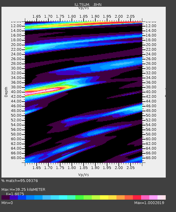
| Estimated Moho Depth: |
39.25 km |
| Estimated Crust Vp/Vs: |
1.69 |
| Assumed Crust Vp: |
6.51 km/s |
| Estimated Crust Vs: |
3.858 km/s |
| Estimated Crust Poisson's Ratio: |
0.23 |
|
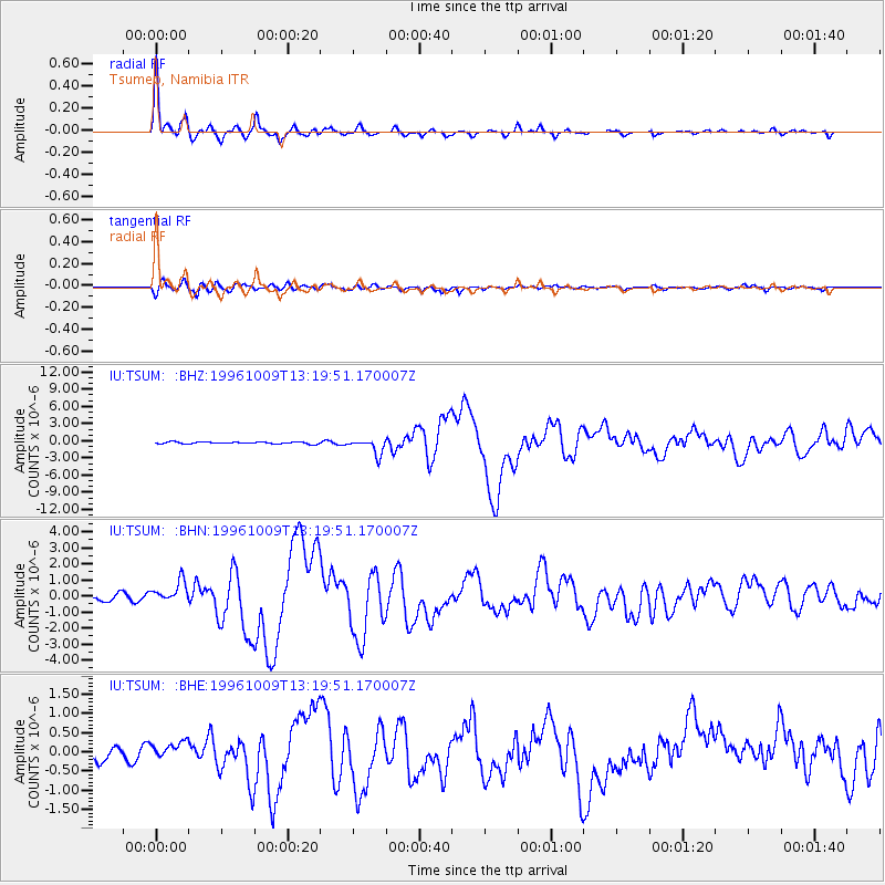
| Radial Match: |
95.09376 % |
| Radial Bump: |
334 |
| Transverse Match: |
80.66419 % |
| Transverse Bump: |
400 |
| SOD ConfigId: |
6273 |
| Insert Time: |
2010-03-04 15:33:08.739 +0000 |
| GWidth: |
2.5 |
| Max Bumps: |
400 |
| Tol: |
0.001 |
|
Signal To Noise
| Channel | StoN | STA | LTA |
| IU:TSUM: :BHN:19961009T13:19:51.170007Z | 1.5764577 | 5.6355566E-7 | 3.5748226E-7 |
| IU:TSUM: :BHE:19961009T13:19:51.170007Z | 0.39237478 | 1.4586332E-7 | 3.717449E-7 |
| IU:TSUM: :BHZ:19961009T13:19:51.170007Z | 8.130949 | 1.3419387E-6 | 1.6504084E-7 |
| Arrivals |
| Ps | 4.4 SECOND |
| PpPs | 15 SECOND |
| PsPs/PpSs | 20 SECOND |


