TSUM Tsumeb, Namibia - Earthquake Result Viewer
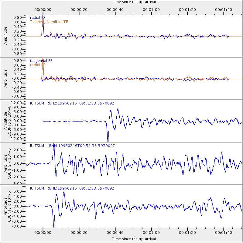
Earthquake location: North Of Ascension Island
Earthquake latitude/longitude: -1.5/-15.2
Earthquake time(UTC): 1996/02/16 (047) 09:44:58 GMT
Earthquake Depth: 10 km
Earthquake Magnitude: 6.0 MB, 6.3 MS, 6.5 UNKNOWN, 6.4 MW
Earthquake Catalog/Contributor: WHDF/NEIC
Network: IU Global Seismograph Network (GSN - IRIS/USGS)
Station: TSUM Tsumeb, Namibia
Lat/Lon: 19.20 S/17.58 E
Elevation: 1240 m
Distance: 36.6 deg
Az: 120.851 deg
Baz: 294.754 deg
Ray Param: 0.07658529
Estimated Moho Depth: 42.5 km
Estimated Crust Vp/Vs: 1.65
Assumed Crust Vp: 6.51 km/s
Estimated Crust Vs: 3.952 km/s
Estimated Crust Poisson's Ratio: 0.21
Radial Match: 89.594376 %
Radial Bump: 313
Transverse Match: 67.17424 %
Transverse Bump: 400
SOD ConfigId: 6273
Insert Time: 2010-03-04 15:33:09.934 +0000
GWidth: 2.5
Max Bumps: 400
Tol: 0.001

Signal To Noise

ChannelStoNSTALTA
IU:TSUM: :BHN:19960216T09:51:33.597009Z1.0075593.5583926E-73.5316964E-7
IU:TSUM: :BHE:19960216T09:51:33.597009Z1.08868126.067343E-75.5731124E-7
IU:TSUM: :BHZ:19960216T09:51:33.597009Z1.08266192.2394109E-72.0684305E-7
Arrivals
Ps4.6 SECOND
PpPs16 SECOND
PsPs/PpSs21 SECOND