You are here: Home > Network List > IU - Global Seismograph Network (GSN - IRIS/USGS) Stations List
> Station TSUM Tsumeb, Namibia > Earthquake Result Viewer
TSUM Tsumeb, Namibia - Earthquake Result Viewer

| Earthquake location: |
Near Coast Of Peru |
| Earthquake latitude/longitude: |
-15.0/-75.7 |
| Earthquake time(UTC): |
1996/11/12 (317) 16:59:44 GMT |
| Earthquake Depth: |
33 km |
| Earthquake Magnitude: |
6.5 MB, 7.3 MS, 7.7 UNKNOWN, 7.7 MW |
| Earthquake Catalog/Contributor: |
WHDF/NEIC |
|
| Network: |
IU Global Seismograph Network (GSN - IRIS/USGS) |
| Station: |
TSUM Tsumeb, Namibia |
| Lat/Lon: |
19.20 S/17.58 E |
| Elevation: |
1240 m |
|
| Distance: |
88.2 deg |
| Az: |
109.265 deg |
| Baz: |
254.868 deg |
| Ray Param: |
0.042751778 |
| Estimated Moho Depth: |
36.75 km |
| Estimated Crust Vp/Vs: |
1.75 |
| Assumed Crust Vp: |
6.51 km/s |
| Estimated Crust Vs: |
3.731 km/s |
| Estimated Crust Poisson's Ratio: |
0.26 |
|
| Radial Match: |
99.11244 % |
| Radial Bump: |
172 |
| Transverse Match: |
96.43042 % |
| Transverse Bump: |
393 |
| SOD ConfigId: |
6273 |
| Insert Time: |
2010-03-04 15:33:18.286 +0000 |
| GWidth: |
2.5 |
| Max Bumps: |
400 |
| Tol: |
0.001 |
|
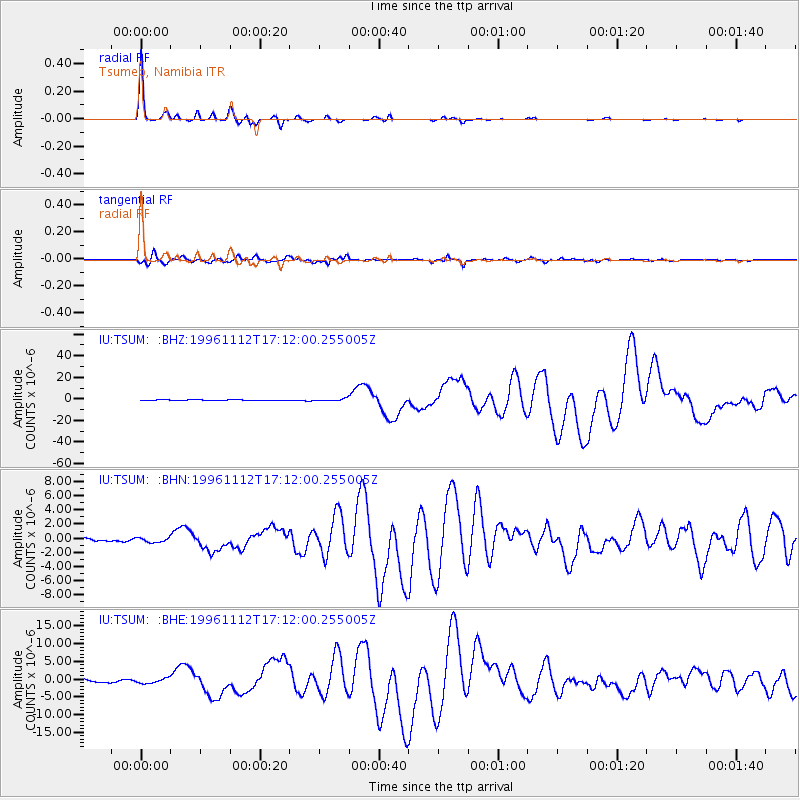
Signal To Noise
| Channel | StoN | STA | LTA |
| IU:TSUM: :BHN:19961112T17:12:00.255005Z | 1.0543334 | 3.0900003E-7 | 2.930762E-7 |
| IU:TSUM: :BHE:19961112T17:12:00.255005Z | 1.5458297 | 6.843276E-7 | 4.426927E-7 |
| IU:TSUM: :BHZ:19961112T17:12:00.255005Z | 3.0210662 | 1.0656004E-6 | 3.5272328E-7 |
| Arrivals |
| Ps | 4.3 SECOND |
| PpPs | 15 SECOND |
| PsPs/PpSs | 19 SECOND |


