You are here: Home > Network List > TA - USArray Transportable Network (new EarthScope stations) Stations List
> Station J01E Myrtle Point, OR, USA > Earthquake Result Viewer
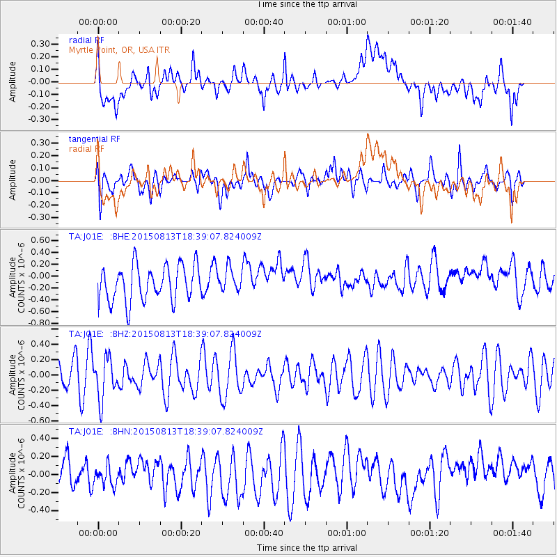
J01E Myrtle Point, OR, USA - Earthquake Result Viewer
*The percent match for this event was below the threshold and hence no stack was calculated.
| Earthquake location: |
South Of Fiji Islands |
| Earthquake latitude/longitude: |
-24.5/-176.5 |
| Earthquake time(UTC): |
2015/08/13 (225) 18:27:21 GMT |
| Earthquake Depth: |
61 km |
| Earthquake Magnitude: |
4.9 MW |
| Earthquake Catalog/Contributor: |
ISC/ISC |
|
| Network: |
TA USArray Transportable Network (new EarthScope stations) |
| Station: |
J01E Myrtle Point, OR, USA |
| Lat/Lon: |
43.16 N/123.93 W |
| Elevation: |
128 m |
|
| Distance: |
82.9 deg |
| Az: |
35.863 deg |
| Baz: |
226.859 deg |
| Ray Param: |
$rayparam |
*The percent match for this event was below the threshold and hence was not used in the summary stack. |
|
| Radial Match: |
46.96142 % |
| Radial Bump: |
400 |
| Transverse Match: |
41.584877 % |
| Transverse Bump: |
400 |
| SOD ConfigId: |
7422571 |
| Insert Time: |
2019-04-20 09:33:18.249 +0000 |
| GWidth: |
2.5 |
| Max Bumps: |
400 |
| Tol: |
0.001 |
|
Signal To Noise
| Channel | StoN | STA | LTA |
| TA:J01E: :BHZ:20150813T18:39:07.824009Z | 1.7814585 | 2.7693025E-7 | 1.554514E-7 |
| TA:J01E: :BHN:20150813T18:39:07.824009Z | 0.5722049 | 1.0793073E-7 | 1.8862254E-7 |
| TA:J01E: :BHE:20150813T18:39:07.824009Z | 0.65775704 | 1.9681902E-7 | 2.992275E-7 |
| Arrivals |
| Ps | |
| PpPs | |
| PsPs/PpSs | |


