You are here: Home > Network List > TA - USArray Transportable Network (new EarthScope stations) Stations List
> Station I23K Minto, Yukon-Koyukuk, AK, USA > Earthquake Result Viewer
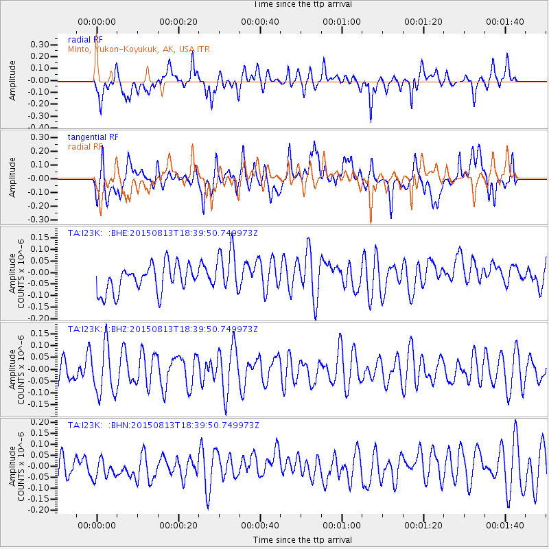
I23K Minto, Yukon-Koyukuk, AK, USA - Earthquake Result Viewer
*The percent match for this event was below the threshold and hence no stack was calculated.
| Earthquake location: |
South Of Fiji Islands |
| Earthquake latitude/longitude: |
-24.5/-176.5 |
| Earthquake time(UTC): |
2015/08/13 (225) 18:27:21 GMT |
| Earthquake Depth: |
61 km |
| Earthquake Magnitude: |
4.9 MW |
| Earthquake Catalog/Contributor: |
ISC/ISC |
|
| Network: |
TA USArray Transportable Network (new EarthScope stations) |
| Station: |
I23K Minto, Yukon-Koyukuk, AK, USA |
| Lat/Lon: |
65.15 N/149.36 W |
| Elevation: |
149 m |
|
| Distance: |
91.7 deg |
| Az: |
11.133 deg |
| Baz: |
204.607 deg |
| Ray Param: |
$rayparam |
*The percent match for this event was below the threshold and hence was not used in the summary stack. |
|
| Radial Match: |
49.945953 % |
| Radial Bump: |
400 |
| Transverse Match: |
50.476818 % |
| Transverse Bump: |
400 |
| SOD ConfigId: |
7422571 |
| Insert Time: |
2019-04-20 09:33:18.551 +0000 |
| GWidth: |
2.5 |
| Max Bumps: |
400 |
| Tol: |
0.001 |
|
Signal To Noise
| Channel | StoN | STA | LTA |
| TA:I23K: :BHZ:20150813T18:39:50.749973Z | 1.7834085 | 1.0596535E-7 | 5.9417314E-8 |
| TA:I23K: :BHN:20150813T18:39:50.749973Z | 0.7916046 | 4.9068554E-8 | 6.198619E-8 |
| TA:I23K: :BHE:20150813T18:39:50.749973Z | 1.6669774 | 9.778525E-8 | 5.866021E-8 |
| Arrivals |
| Ps | |
| PpPs | |
| PsPs/PpSs | |


