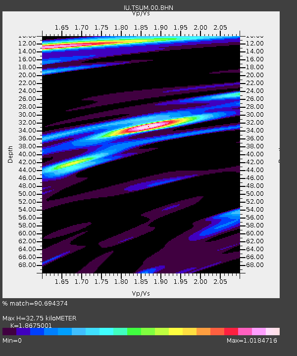
TSUM Tsumeb, Namibia - Earthquake Result Viewer
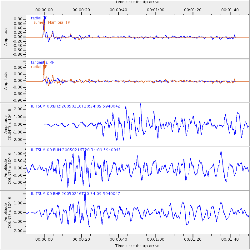
Earthquake location: Southern Mid-Atlantic Ridge
Earthquake latitude/longitude: -36.3/-16.6
Earthquake time(UTC): 2005/02/16 (047) 20:27:52 GMT
Earthquake Depth: 10 km
Earthquake Magnitude: 6.0 MB, 6.1 MS, 6.6 MW, 6.5 MW
Earthquake Catalog/Contributor: WHDF/NEIC
Network: IU Global Seismograph Network (GSN - IRIS/USGS)
Station: TSUM Tsumeb, Namibia
Lat/Lon: 19.20 S/17.58 E
Elevation: 1240 m
Distance: 34.5 deg
Az: 69.604 deg
Baz: 233.226 deg
Ray Param: 0.0777286
Estimated Moho Depth: 32.75 km
Estimated Crust Vp/Vs: 1.87
Assumed Crust Vp: 6.51 km/s
Estimated Crust Vs: 3.486 km/s
Estimated Crust Poisson's Ratio: 0.30
Radial Match: 90.694374 %
Radial Bump: 362
Transverse Match: 64.091255 %
Transverse Bump: 400
SOD ConfigId: 2455
Insert Time: 2010-03-04 15:33:41.426 +0000
GWidth: 2.5
Max Bumps: 400
Tol: 0.001

Signal To Noise

ChannelStoNSTALTA
IU:TSUM:00:BHN:20050216T20:34:09.594004Z1.67960322.0786912E-71.2376086E-7
IU:TSUM:00:BHE:20050216T20:34:09.594004Z4.18751573.301311E-77.8836976E-8
IU:TSUM:00:BHZ:20050216T20:34:09.594004Z3.32681445.3400305E-71.6051483E-7
Arrivals
Ps4.7 SECOND
PpPs13 SECOND
PsPs/PpSs18 SECOND