You are here: Home > Network List > IU - Global Seismograph Network (GSN - IRIS/USGS) Stations List
> Station TSUM Tsumeb, Namibia > Earthquake Result Viewer
TSUM Tsumeb, Namibia - Earthquake Result Viewer
| Earthquake location: |
Southern Sumatra, Indonesia |
| Earthquake latitude/longitude: |
-2.8/100.2 |
| Earthquake time(UTC): |
2007/09/12 (255) 11:40:01 GMT |
| Earthquake Depth: |
35 km |
| Earthquake Magnitude: |
5.5 MB |
| Earthquake Catalog/Contributor: |
WHDF/NEIC |
|
| Network: |
IU Global Seismograph Network (GSN - IRIS/USGS) |
| Station: |
TSUM Tsumeb, Namibia |
| Lat/Lon: |
19.20 S/17.58 E |
| Elevation: |
1240 m |
|
| Distance: |
82.1 deg |
| Az: |
251.117 deg |
| Baz: |
90.27 deg |
| Ray Param: |
0.047057763 |
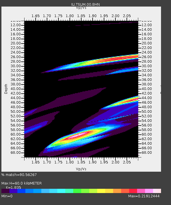
| Estimated Moho Depth: |
60.0 km |
| Estimated Crust Vp/Vs: |
1.84 |
| Assumed Crust Vp: |
6.51 km/s |
| Estimated Crust Vs: |
3.548 km/s |
| Estimated Crust Poisson's Ratio: |
0.29 |
|
| Radial Match: |
90.56267 % |
| Radial Bump: |
400 |
| Transverse Match: |
59.221653 % |
| Transverse Bump: |
400 |
| SOD ConfigId: |
2564 |
| Insert Time: |
2010-03-04 15:34:02.646 +0000 |
| GWidth: |
2.5 |
| Max Bumps: |
400 |
| Tol: |
0.001 |
|
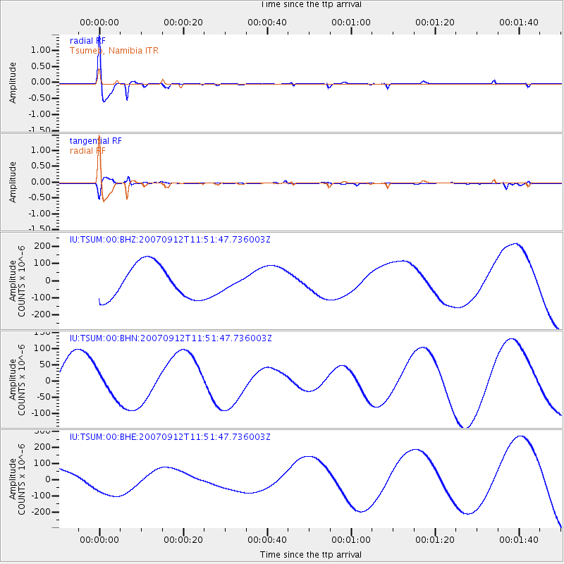
Signal To Noise
| Channel | StoN | STA | LTA |
| IU:TSUM:00:BHN:20070912T11:51:47.736003Z | 0.64719695 | 3.9741568E-5 | 6.140568E-5 |
| IU:TSUM:00:BHE:20070912T11:51:47.736003Z | 2.6537313 | 1.1057905E-4 | 4.166927E-5 |
| IU:TSUM:00:BHZ:20070912T11:51:47.736003Z | 0.28418225 | 2.7972323E-5 | 9.843092E-5 |
| Arrivals |
| Ps | 7.9 SECOND |
| PpPs | 25 SECOND |
| PsPs/PpSs | 33 SECOND |


