You are here: Home > Network List > IU - Global Seismograph Network (GSN - IRIS/USGS) Stations List
> Station TSUM Tsumeb, Namibia > Earthquake Result Viewer
TSUM Tsumeb, Namibia - Earthquake Result Viewer
| Earthquake location: |
Java, Indonesia |
| Earthquake latitude/longitude: |
-5.9/107.7 |
| Earthquake time(UTC): |
2007/08/08 (220) 17:04:57 GMT |
| Earthquake Depth: |
291 km |
| Earthquake Magnitude: |
6.1 MB |
| Earthquake Catalog/Contributor: |
WHDF/NEIC |
|
| Network: |
IU Global Seismograph Network (GSN - IRIS/USGS) |
| Station: |
TSUM Tsumeb, Namibia |
| Lat/Lon: |
19.20 S/17.58 E |
| Elevation: |
1240 m |
|
| Distance: |
88.2 deg |
| Az: |
251.001 deg |
| Baz: |
95.597 deg |
| Ray Param: |
0.042074576 |
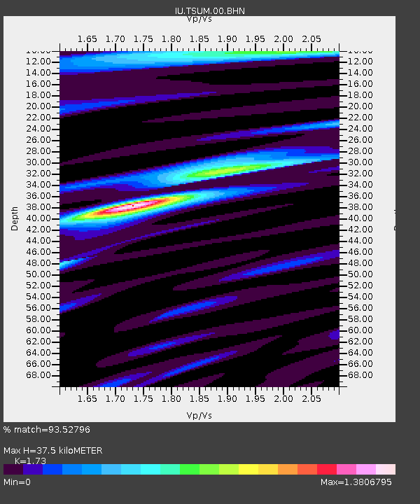
| Estimated Moho Depth: |
37.5 km |
| Estimated Crust Vp/Vs: |
1.73 |
| Assumed Crust Vp: |
6.51 km/s |
| Estimated Crust Vs: |
3.763 km/s |
| Estimated Crust Poisson's Ratio: |
0.25 |
|
| Radial Match: |
93.52796 % |
| Radial Bump: |
400 |
| Transverse Match: |
84.200195 % |
| Transverse Bump: |
400 |
| SOD ConfigId: |
2564 |
| Insert Time: |
2010-03-04 15:34:06.451 +0000 |
| GWidth: |
2.5 |
| Max Bumps: |
400 |
| Tol: |
0.001 |
|

Signal To Noise
| Channel | StoN | STA | LTA |
| IU:TSUM:00:BHN:20070808T17:16:44.73502Z | 1.1884686 | 2.9162382E-7 | 2.453778E-7 |
| IU:TSUM:00:BHE:20070808T17:16:44.73502Z | 2.8350625 | 6.8206487E-7 | 2.4058195E-7 |
| IU:TSUM:00:BHZ:20070808T17:16:44.73502Z | 6.6796513 | 2.1477604E-6 | 3.215378E-7 |
| Arrivals |
| Ps | 4.3 SECOND |
| PpPs | 15 SECOND |
| PsPs/PpSs | 20 SECOND |


