You are here: Home > Network List > CN - Canadian National Seismograph Network Stations List
> Station INK INUVIK, NT > Earthquake Result Viewer
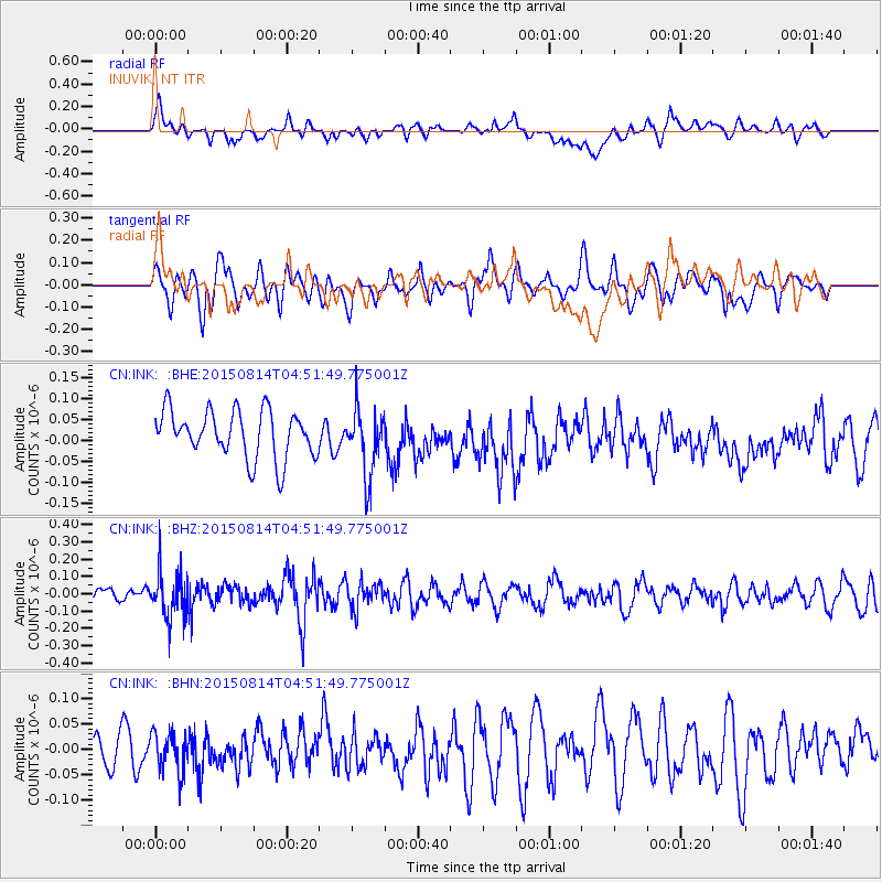
INK INUVIK, NT - Earthquake Result Viewer
*The percent match for this event was below the threshold and hence no stack was calculated.
| Earthquake location: |
Hokkaido, Japan Region |
| Earthquake latitude/longitude: |
42.8/143.1 |
| Earthquake time(UTC): |
2015/08/14 (226) 04:43:44 GMT |
| Earthquake Depth: |
85 km |
| Earthquake Magnitude: |
5.2 MW |
| Earthquake Catalog/Contributor: |
ISC/ISC |
|
| Network: |
CN Canadian National Seismograph Network |
| Station: |
INK INUVIK, NT |
| Lat/Lon: |
68.31 N/133.53 W |
| Elevation: |
44 m |
|
| Distance: |
48.7 deg |
| Az: |
29.439 deg |
| Baz: |
283.246 deg |
| Ray Param: |
$rayparam |
*The percent match for this event was below the threshold and hence was not used in the summary stack. |
|
| Radial Match: |
49.69997 % |
| Radial Bump: |
400 |
| Transverse Match: |
55.628902 % |
| Transverse Bump: |
400 |
| SOD ConfigId: |
7422571 |
| Insert Time: |
2019-04-20 09:38:03.671 +0000 |
| GWidth: |
2.5 |
| Max Bumps: |
400 |
| Tol: |
0.001 |
|
Signal To Noise
| Channel | StoN | STA | LTA |
| CN:INK: :BHZ:20150814T04:51:49.775001Z | 3.0333393 | 1.3756306E-7 | 4.535037E-8 |
| CN:INK: :BHN:20150814T04:51:49.775001Z | 0.9078335 | 3.850955E-8 | 4.2419178E-8 |
| CN:INK: :BHE:20150814T04:51:49.775001Z | 1.4232876 | 8.004752E-8 | 5.624128E-8 |
| Arrivals |
| Ps | |
| PpPs | |
| PsPs/PpSs | |


