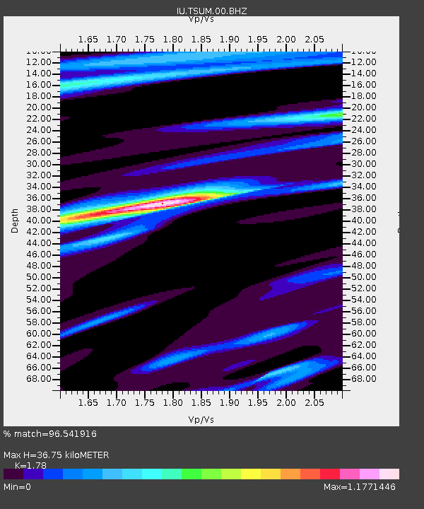
TSUM Tsumeb, Namibia - Earthquake Result Viewer
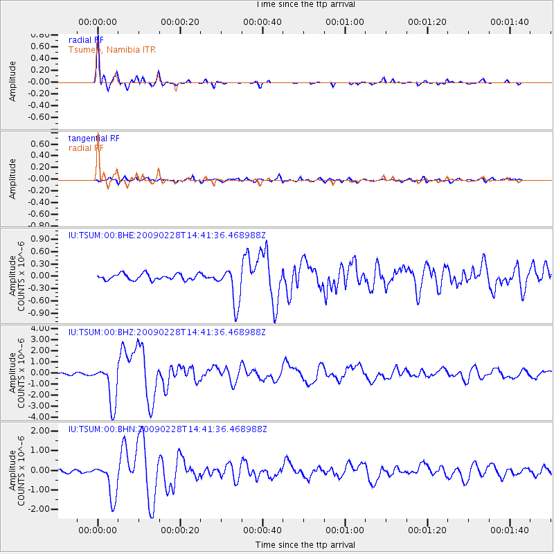
Earthquake location: South Sandwich Islands Region
Earthquake latitude/longitude: -60.5/-24.8
Earthquake time(UTC): 2009/02/28 (059) 14:33:06 GMT
Earthquake Depth: 15 km
Earthquake Magnitude: 6.1 MB, 6.1 MS, 6.3 MW, 6.3 MW
Earthquake Catalog/Contributor: WHDF/NEIC
Network: IU Global Seismograph Network (GSN - IRIS/USGS)
Station: TSUM Tsumeb, Namibia
Lat/Lon: 19.20 S/17.58 E
Elevation: 1260 m
Distance: 51.0 deg
Az: 55.058 deg
Baz: 205.403 deg
Ray Param: 0.06767952
Estimated Moho Depth: 36.75 km
Estimated Crust Vp/Vs: 1.78
Assumed Crust Vp: 6.51 km/s
Estimated Crust Vs: 3.657 km/s
Estimated Crust Poisson's Ratio: 0.27
Radial Match: 96.541916 %
Radial Bump: 241
Transverse Match: 81.954155 %
Transverse Bump: 400
SOD ConfigId: 2658
Insert Time: 2010-03-04 15:34:27.017 +0000
GWidth: 2.5
Max Bumps: 400
Tol: 0.001

Signal To Noise

ChannelStoNSTALTA
IU:TSUM:00:BHZ:20090228T14:41:36.468988Z20.2947981.9205727E-69.463374E-8
IU:TSUM:00:BHN:20090228T14:41:36.468988Z9.436429.568238E-71.013969E-7
IU:TSUM:00:BHE:20090228T14:41:36.468988Z6.3752864.7385203E-77.4326394E-8
Arrivals
Ps4.7 SECOND
PpPs15 SECOND
PsPs/PpSs19 SECOND